Parameters
Select which parameters you want to examine:
- Object parameters (e.g. - 'P001', 'P002', etc. tables)
- POSS I Field parameters ('plates' table)
- Astrometric Fit Parameters ('astrom' table)
- Photometric Fit Parameters ('photom' table)
- Photometric Standards ('standards' table)
- POSS I scanned data removed from MAPS Catalog ('cuts' table)
- All the parameters in the MAPS Catalog database (list all of the above)
All of the table parameters follow
'object' Table Parameters:
Object data is broken up into 632 database tables, each with the name of the POSS I field the objects are on (e.g. 'P001', 'P002', etc). The following parameters are stored for each of the over 89 million objects in the MAPS Catalog:
| Field Name | Definition |
|---|---|
| plateid | MAPS POSS I Field Number |
| starnumO, starnumE | Image raster number for the O and E plates respectively. The plateid combined with starnumO uniquely identifies an object in the MAPS Catalog and thus the official IAU designation for objects in the MAPS Catalog is "MAPS Pplateid-starnumO" (e.g. - The object with starnumO '34256' and plateid '1' would have the IAU designation 'MAPS P001-0034256').
NON-UNIQUENESS WARNING: First of all, because of the nature of the POSS I survey, a single object in the sky can appear on multiple POSS I plates if they overlap in their sky coverage. So a single object in the sky can have mutliple MAPS Catalog records. Furthermore, the E raster number may not be unique for a given POSS I field. Object matching was done from O to E, so sometimes a single E plate object was the closest counterpart to two O plate images. Such (rare) cases are flagged in the dupl parameter (see below). |
| ra | Right Ascension (equatorial B1950.0 coordinates on the FK4 system). Stored internally as a 1000*seconds integer. |
| decl | Declination (equatorial B1950.0 coordinates on the FK4 system). Stored internally as a 1000*arcseconds integer. |
| raJ | Right Ascension (ecliptic J2000.0 coordinates on the FK5 system). Stored internally as a 1000*seconds integer. |
| declJ | Declination (ecliptic J2000.0 coordinates on the FK5 system). Stored internally as a 1000*arcseconds integer. |
| l | Galactic Longitude (lII system). Stored internally as a 1000*arcseconds integer. |
| b | Galactic Latitude (lII system). Stored internally as a 1000*arcseconds integer. |
| Ebv_S | E(B-V) for this position based on
the bilinear interpolation of the dust maps
from Schlegel,
Finkbeiner, & Davis (1998). If we combine the UV -
NIR extinction law from Cardelli, Clayton and Mathis
1989, ApJ, 345, 245 with conversion of E(B-V) to A_V by
assuming
A_V = 3*E(B-V),then the extinction corrections in the POSS I bandpasses becomes: A_O = 1.4646 * A_V = 1.4646 * 3*E(B-V) A_E = 0.8120 * A_V = 0.8120 * 3*E(B-V) |
| magiO, magiE | Integrated magnitude for this object on the O and E plates respectively. This magnitude is appropriate for extended objects. |
| magdO, magdE | "stellar" magnitude (determined from the diameter-magnitude relation) for this object on the O and E plates respectively. This magnitude is appropriate for point sources. |
| colori | O-E color for this object (computed using integrated magnitudes) |
| colord | O-E color (computed using "stellar" magnitudes) |
| mean_sbO, mean_sbE | Mean Surface Brightness (in magnitudes/arcsec^2) for this object on the O and E plates respectively. |
| diaO, diaE | Major-axis diameter for this object on the O and E plates respectively (in arcseconds). NOTE: Diameters of 0.00 may be stored for some objects where the ellipticity was listed as 1.00 or -0.001. All these objects have flagO or flagE denoting the reason for disregarding the validity of the data. |
| ellO, ellE | The ellipticity (based on a moments analysis of the entire image) for this object on the O and E plates respectively. NOTE: Cases where the ellipticity could not be determined are listed as having ellipticity -0.001. And ellipticity of greater than 0.95 likely means the object is a scratch or crossed a striped boundary in the MAPS scans. The flagO and flagE fields note stripe crossing objects, but not scratches. |
| thetaO, thetaE | The position angle (based on a moments analysis of the entire image) for this object on the O and E plates respectively. This is measured in degrees East of North in B1950.0 coordinates. NOTE: A position angle of 0.00 may be stored for some objects where the ellipticity was listed as 1.00 or -0.001. This value is invalid in these cases. To eliminate all non-real 0.00 position angles from your sample, check that flagO and/or flagE also equal 0. |
| thetaJO, thetaJE | Same as thetaO or thetaE except this is measured in J2000.0 coordinates and computed based on thetaO or thetaE. NOTE: If the position angle in B1950.0 (thetaO or thetaE) equals 0.00, be sure to check that the corresponding flagO and/or flagE also equal 0 to be sure thetaJO and/or thetaJE is valid. |
| thetaGO, thetaGE | Same as thetaO or thetaE except this is measured in Galactic coordinates and computed based on thetaO or thetaE. NOTE: If the position angle in B1950.0 (thetaO or thetaE) equals 0.00, be sure to check that the corresponding flagO and/or flagE also equal 0 to be sure thetaGO and/or thetaGE is valid. |
| galnodO, galnodE | An estimate of the probability that object is a galaxy based on the O and E plate images respectively. For determining if a object is a galaxy, the O plate galnod value is the more appropriate value as the images were generally better on the O plates. |
| reffO, reffE | The half-light radius for this object on the O and E plates respectively (in arcseconds) |
| mir1O, mir2O, mir1E, mir2E | The first and second moments of the flux in this object's image on the O and E plates respectively. This is measured in degrees East of North. |
| psatO, psatE | The percentage saturation of this image on the O and E plates respectively. One of the major problems with photographic plates is that when all the silver halides in the emulsion have reacted with incoming light, additional light can no longer be detected. That is, the image has saturated. The more saturated an image is, the more difficult it can be to extract accurate photometric parameters for the object. |
| c32O, c42O, c32E, c42E | The C(r75/r50) [c32] and C(r100/r50) [c42] concentration indices for this object on the O and E plates respectively. The concentration index is a measure of how centrally concentrated the light in a object is. |
| tavgO, tskyO, tavgE, tskyE | The average transmittance and sky transmittance for this object on the O and E plates respectively. |
| XsctO, YsctO, XsctE, YsctE | The X and Y position for the centroid of this object (and the region around it) on the O and E plates respectively. Measured in units of EREs (1 ERE = 0.366μ, 0".0245). |
| flagO, flagE | This is a flag for bad image data for this object on the O and E plates respectively. The flags have the following meanings:
|
| dupl | The number of times this starnumE was matched to a starnumO. In most cases this should be "1" (a unique cross-identification). |
'plates' Table Parameters
The 'plates' database table stores information specific to each POSS I field in the MAPS Catalog (Why 'plates'? Because 'fields' is a reserved word in MySQL and can't be used as the name of a database table). The following parameters are stored for each field in the MAPS Catalog:
| Field Name | Definition |
|---|---|
| possfield | MAPS POSS I Field Name |
| possnumber | MAPS POSS I Field Number |
| mln | Palomar Sky Survey Emulsion Number |
| epoch | Date of Observation |
| numobjs | Number of objects in the field |
| numstars | Number of objects classed as stars |
| numgalax | Number of objects classed as galaxies (non stellar) |
| ramin, ramax | Minimum and Maximum Right Ascension (equatorial B1950.0 coordinates on the FK4 system). Stored internally as a 1000*seconds integer. If the field crosses 0/24 hours, then the minra stores the value "below" 24 hours and maxra stores the value "above" 0 hours. Such 0/24 hour crossing fields can thus be easily identified because their maxra are less than their minra. |
| declmin, declmax | Minimum and Maximum Declination (equatorial B1950.0 coordinates on the FK4 system). Stored internally as a 1000*arcseconds integer. |
| raJmin, raJmax | Minimum and Maximum Right Ascension (ecliptic J2000.0 coordinates on the FK5 system). Same format as ramin and ramax. |
| declJmin, declJmax | Minimum and Maximum Declination (ecliptic J2000.0 coordinates on the FK5 system). Same format as declmin and declmax. |
| lmin, lmax | Minimum and Maximum Galactic Longitude (lII system). Stored internally as a 1000*arcseconds integer. If the field crosses 0/24 hours, then the minl stores the value "below" 360 degrees and maxl stores the value "above" 0 degrees. Such 0/360 degree crossing fields can thus be easily identified because their maxl are less than their minl. |
| bmin, bmax | Minimum and Maximum Galactic Latitude (lII system). Stored internally as a 1000*arcseconds integer. |
| Ebv_Smin, Ebv_Smax | Minimum and Maximum E(B-V) in this POSS I field based on the bilinear interpolation of the dust maps from Schlegel, Finkbeiner, & Davis (1998). See the discussion below on the Ebv_S parameter for the object Tables for a description of how to compute extinction corrections in the POSS I bandpasses. |
| magdomax, magdemax | Limiting diameter-based (stellar) magnitude on the O and E plates, respectively. |
| magiomax, magiemax | Limiting integrated magnitude on the O and E plates, respectively. |
| seeingo, seeinge | Seeing estimate (in arcseconds) from the point spread function (PSF) on the O and E plates, respectively. |
| thresho, threshe | Surface brightness limit from PSF (in magnitudes/arcsec^2) on the O and E plates, respectively. |
| skyo, skye | Sky surface brightness estimate from PSF (in magnitudes/arcsec^2) on the O and E plates, respectively. |
| csrco, csrce | Photometric calibration sources on the O and E plates, respectively.
|
| mindo, maxdo, minde, maxde | Minimum and Maximum diameters for the calibration in EREs (i.e. - Encoder Resolution Elements where 1 ERE = 0.366μ, 0".0245). Note that these are "areal" diameters, not major-axis diameters. "Areal" diameters are determined by taking the area of the object in square ERE and dividing it by pi, then taking the square root. For non-circular objects, this is not an accurate representation of the diameter. However, most of the stars used in the photometric calibration should be fairly circular. |
| rms[1-3]o, rms[1-3]e | Photometric calibration fit RMS for different magnitude ranges
|
'astrom' Table Parameters
The 'astrom' database table stores information describing the astrometric fit to each POSS I field in the MAPS Catalog. The following astrometric fit parameters are stored for each field in the MAPS Catalog:
'photom' Table Parameters
The 'photom' database table stores information describing the photometric fits performed (both for 'stellar' and 'integrated' magnitudes) for each POSS I plate in the MAPS Catalog. The following photometric fit parameters are stored for each field in the MAPS Catalog:
| Field Name | Definition |
|---|---|
| possfield | MAPS POSS I Field Name |
| possnumber | MAPS POSS I Field Number |
| emul | The emulsion of the plate. Either 'O' for the blue-sensitive Kodak 103a-O emulsion and 'E' for the red-sensitive Kodak 103a-E emulsion. The plot below shows the spectral response of these emulsions versus UBVRI filters.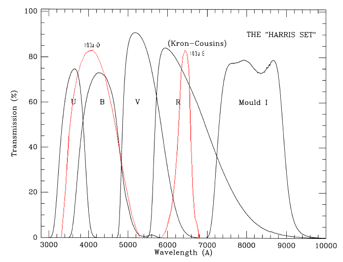 |
| sb0, r0, beta, rm, gamma | These are the values of the coefficients used in the fit
of the diameter-magnitude relation used to determine the magnitude of a
point-like (non-extended) object. The function fit was a variant of the King and Kormendy form of the PSF functions (King (1971) and Kormendy (1973)) and has the form: mag(diam) = SB0 + 2.5 log10[(1+(diam/R0)^2)^BETA + (diam/RM)^GAMMA]where "diam" is the "areal" diameter in EREs (By "areal" diameter, we mean the diameter determined by taking the surface area of the scanned object in square EREs, and then computing the diameter of a circle with the same area.). The five parameters fit to the data are SB0, BETA, R0, GAMMA, and RM. This fit is accomplished via a non-linear least squares fit and is done independently for the O and E plates. |
| Nstars | Number of stars used in the fit |
| Nflag | Number of stars flagged and not used in the fit |
| calsrc | Photometric calibration sources on the O and E plates, respectively.
|
| mindia, maxdia | The "areal" diameters (in ERE) of the smallest and largest stars used in the fit |
| rms | The RMS of the entire fit for the diameter-magnitude relation. If undefined, its value is set to "99.9000". |
| rms_08_14 | The RMS of fit for the diameter-magnitude relation between 8th and 14th magnitude. If undefined, its value is set to "99.9000". |
| rms_14_20 | The RMS of fit for the diameter-magnitude relation between 14th and 20th magnitude. If undefined, its value is set to "99.9000". |
| rms_20_22 | The RMS of fit for the diameter-magnitude relation between 20th and 22th magnitude. If undefined, its value is set to "99.9000". |
| D_sky | The photographic grain density of the sky determined from a low-resolution background scan of the plate. |
| D_max, alpha_DI, beta_DI, gamma_DI | The density-to-intensity relation used to compute the integrated
magnitudes of non-stellar (galactic) images is fit by a function developed by
Greg Aldering The density-to-intensity function is assumed to have
a form:
D(I) = D_MAX*(1 - exp[ALPHA*(I^(BETA*(I^GAMMA)))])motivated by a physical model for response of photographic grains to incoming photons. Note that in addition to the four parameters fit (ALPHA, BETA, GAMMA, and D_MAX), the intensity I in the above equation is (I_STAR+I_SKY)/I_REF, so I_SKY is another parameter to be fit. As before, the fit is performed independently on the O and E plates. This allows a check of the D-to-I transformation using the fit I_SKY. |
| I_sky | Estimate of the sky intensity based the sky density and the fit of D(I).
This sky intensity cooresponds to flux per square ERE on the and so one could convert this to sky surface brightness, mu_sky, in mag/arcsecond^2, can be computed from this intensity using the relation:
mu_sky = -2.5*log10(I_sky/(ERE^2/arcsecond^2))where (ERE^2/arcsecond^2) = (0.0245 ERE/arcsecond)^2. |
| I_ref | Estimate of the reference intensity. |
| I_thresh | Estimate of the threshold intensity. |
| seeing | The seeing of the sky are determined by the PSF of stars used in fitting the density-to-intensity relation. |
'standards' Table Parameters
The 'standards' database table stores information describing standard stars used to establish the 'stellar' magnitude photometric fits for each POSS I plate in the MAPS Catalog. The following parameters are stored for each photometric standard used in the MAPS Catalog:
| Field Name | Definition |
|---|---|
| possfield | MAPS POSS I Field Name |
| possnumber | MAPS POSS I Field Number |
| objectname | The full MAPS Catalog object corresponding to this photometric standard when available.
Otherwise, two other kinds of "names" may be provided:
|
| standard | The names of the standards indicate where data was obtained.
|
| Vmag, Verr, BVmag, BVerr, VRmag, VRerr | The standards' V, B-V, and V-R magnitude/colors and their respective errors. Note that for Guide Star Catalog standards, the reported V-R magnitudes come from applying a transformation from V and B-V to B-R based on Landolt standards as described in Larsen (1996) and Larsen (2003). |
| night | The night the observation was made, if known |
| Odia, Edia | The "areal" diameter (in EREs) of this object from the O and E plate scans respectively (By "areal" diameter, we mean the diameter determined by taking the surface area of the scanned object in square EREs, and then computing the diameter of a circle with the same area.). |
| Omag, Emag | The O and E magnitudes of the objects, respectively, computed from B,V,R magnitudes using standard transformations. These are NOT necessarily the final magnitude recorded in the MAP Catalog. |
| Oerr, Eerr | The O and E magniude uncertainties, respectively. |
| Oresid, Eresid | The residuals of the O and E magnitudes, respectively, to the diameter-magnitude function fit. |
| used | Records whether the star was used in the final fit of the diameter-magnitude relation on both plates (OE), the O plate only (O), the E plate only (E), or neither (N). |
'cuts' Table Parameters
The 'cuts' database table stores information describing which portions of a POSS I field were deleted or removed from the MAPS Catalog due to their either being a diffraction halo around a bright star, plate defects, or extended nebulosity which can't be processed. The following parameters are stored for each cut performed on the MAPS Catalog: