Finder Charts
The queried region:
| Longitude/Right Ascension: | 23:11:28.5 | |
| Latitude/Declination: | -6.2525031 (degrees) | |
| Field Width: | 10.0 (arcminutes) | |
| Coordinate System: | J2000 |
|
MAPS Catalog Finder Chart Query Results
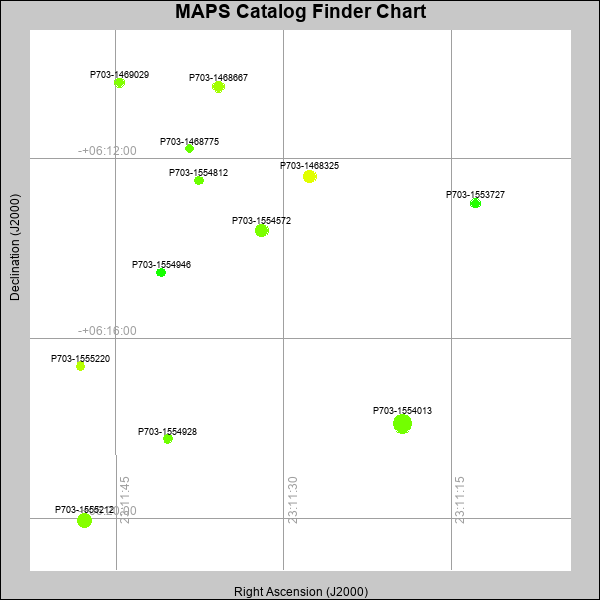 |
| Stars (point sources) are represented by filled circles. Galaxies (Extended objects) are represented by ellipses. The size of the object is an indication of its brightness (the O magnitude is printed next to each object). The color of the object indicates the actual color of the object. |
Your search returned 12 objects.
Download an ASCII text file of your results: /downloads/MAPS_output.2642495320.txt
MAPS Catalog Data for 12matching objects:
| IAU Name | raJ | declJ | magdo | magio | colord | colori | diao | thetaJO | ello | galnodo |
|---|---|---|---|---|---|---|---|---|---|---|
| MAPS-P703-1554013 | 23:11:19.393 | -06:17:53.47 | 12.25 | 16.77 | +1.03 | +1.50 | 20.46 | 7.94 | 0.019 | 0.010 |
| MAPS-P703-1555212 | 23:11:47.799 | -06:20:02.62 | 13.35 | 17.18 | +1.12 | +1.40 | 15.89 | 49.59 | 0.004 | 0.010 |
| MAPS-P703-1554572 | 23:11:31.961 | -06:13:35.73 | 14.25 | 17.55 | +1.06 | +1.49 | 13.94 | 72.23 | 0.032 | 0.010 |
| MAPS-P703-1468325 | 23:11:27.654 | -06:12:23.34 | 14.35 | 17.58 | +1.72 | +1.76 | 13.83 | 53.76 | 0.045 | 0.010 |
| MAPS-P703-1468667 | 23:11:35.812 | -06:10:24.18 | 15.04 | 17.74 | +1.31 | +1.57 | 12.93 | 17.80 | 0.097 | 0.010 |
| MAPS-P703-1469029 | 23:11:44.683 | -06:10:18.91 | 16.34 | 18.22 | +1.11 | +1.50 | 10.77 | 23.35 | 0.082 | 0.010 |
| MAPS-P703-1553727 | 23:11:12.850 | -06:12:59.13 | 16.74 | 18.36 | +0.61 | +1.38 | 10.12 | 21.53 | 0.068 | 0.010 |
| MAPS-P703-1554946 | 23:11:40.952 | -06:14:31.80 | 17.11 | 18.45 | +0.55 | +1.31 | 9.70 | 17.13 | 0.089 | 0.010 |
| MAPS-P703-1555220 | 23:11:48.153 | -06:16:36.47 | 17.21 | 18.45 | +1.43 | +1.55 | 9.21 | 17.59 | 0.017 | 0.010 |
| MAPS-P703-1554812 | 23:11:37.585 | -06:12:28.65 | 17.34 | 18.65 | +0.98 | +1.48 | 9.24 | 141.66 | 0.059 | 0.020 |
| MAPS-P703-1468775 | 23:11:38.418 | -06:11:46.29 | 17.70 | 18.73 | +0.93 | +1.37 | 8.49 | 154.03 | 0.002 | 0.030 |
| MAPS-P703-1554928 | 23:11:40.351 | -06:18:13.62 | 17.85 | 18.67 | +1.01 | +1.20 | 9.04 | 24.93 | 0.160 | 0.010 |
This page was generated at Fri, 26 Apr 2024 09:53:20 -0500 and took 0.194 seconds to serve.