Finder Charts
The queried region:
| Longitude/Right Ascension: | 20:00:11.2 | |
| Latitude/Declination: | -31.8873056 (degrees) | |
| Field Width: | 10.0 (arcminutes) | |
| Coordinate System: | J2000 |
|
MAPS Catalog Finder Chart Query Results
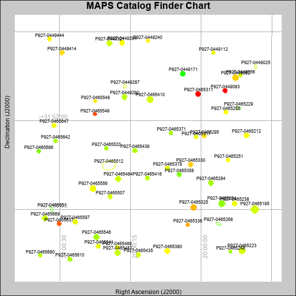 |
| Stars (point sources) are represented by filled circles. Galaxies (Extended objects) are represented by ellipses. The size of the object is an indication of its brightness (the O magnitude is printed next to each object). The color of the object indicates the actual color of the object. |
Your search returned 58 objects.
Download an ASCII text file of your results: /downloads/MAPS_output.26424172701.txt
MAPS Catalog Data for 58matching objects:
| IAU Name | raJ | declJ | magdo | magio | colord | colori | diao | thetaJO | ello | galnodo |
|---|---|---|---|---|---|---|---|---|---|---|
| MAPS-P927-0465512 | 20:00:19.529 | -31:54:00.54 | 10.54 | 15.89 | +1.74 | +1.71 | 36.48 | 98.01 | 0.354 | 1.000 |
| MAPS-P927-0465195 | 19:59:48.591 | -31:55:59.71 | 14.32 | 16.88 | +1.61 | +1.09 | 17.16 | 15.48 | 0.308 | 0.000 |
| MAPS-P927-0465264 | 19:59:55.543 | -31:55:43.99 | 14.37 | 16.88 | +1.18 | +0.91 | 14.95 | 178.03 | 0.101 | 0.010 |
| MAPS-P927-0465223 | 19:59:51.248 | -31:57:51.16 | 14.70 | 17.02 | +1.65 | +1.06 | 14.08 | 7.67 | 0.079 | 0.010 |
| MAPS-P927-0449062 | 19:59:52.687 | -31:50:03.42 | 14.79 | 17.00 | +2.24 | +1.27 | 13.85 | 5.64 | 0.072 | 0.010 |
| MAPS-P927-0465325 | 20:00:01.537 | -31:55:53.72 | 14.95 | 17.07 | +2.39 | +1.31 | 13.52 | 9.29 | 0.070 | 0.010 |
| MAPS-P927-0465546 | 20:00:22.225 | -31:57:14.29 | 15.10 | 17.15 | +1.32 | +0.96 | 13.11 | 153.31 | 0.052 | 0.010 |
| MAPS-P927-0465487 | 20:00:17.709 | -31:57:56.46 | 15.17 | 17.20 | +1.51 | +1.08 | 13.24 | 179.80 | 0.090 | 0.010 |
| MAPS-P927-0465484 | 20:00:17.577 | -31:54:37.22 | 15.20 | 17.15 | +1.57 | +0.96 | 13.09 | 13.09 | 0.075 | 0.010 |
| MAPS-P927-0465556 | 20:00:22.915 | -31:55:02.93 | 15.38 | 17.41 | +1.82 | +1.14 | 13.72 | 61.76 | 0.202 | 0.100 |
| MAPS-P927-0465380 | 20:00:07.146 | -31:57:52.01 | 15.51 | 17.34 | +1.95 | +1.26 | 12.79 | 13.87 | 0.115 | 0.010 |
| MAPS-P927-0465410 | 20:00:10.832 | -31:51:02.86 | 15.65 | 17.49 | +1.64 | +1.21 | 14.47 | 18.57 | 0.337 | 0.010 |
| MAPS-P927-0449321 | 20:00:19.416 | -31:48:30.59 | 15.71 | 17.37 | +1.61 | +1.09 | 12.30 | 173.88 | 0.098 | 0.010 |
| MAPS-P927-0465284 | 19:59:57.893 | -31:54:48.04 | 15.81 | 17.37 | +1.34 | +0.98 | 11.84 | 19.64 | 0.056 | 0.010 |
| MAPS-P927-0449292 | 20:00:16.235 | -31:50:56.29 | 15.90 | 17.54 | +1.47 | +1.05 | 11.85 | 13.19 | 0.083 | 0.010 |
| MAPS-P927-0465597 | 20:00:26.672 | -31:56:32.72 | 16.07 | 17.51 | +1.77 | +1.12 | 11.51 | 19.27 | 0.078 | 0.010 |
| MAPS-P927-0465238 | 19:59:52.859 | -31:55:43.76 | 16.09 | 17.50 | +1.83 | +1.16 | 11.39 | 4.89 | 0.064 | 0.010 |
| MAPS-P927-0465311 | 20:00:00.676 | -31:50:47.36 | 16.10 | 17.56 | +3.79 | +1.49 | 11.18 | 28.27 | 0.032 | 0.010 |
| MAPS-P927-0449171 | 20:00:03.892 | -31:49:53.12 | 16.12 | 17.56 | +0.59 | +0.72 | 11.55 | 7.97 | 0.097 | 0.010 |
| MAPS-P927-0449294 | 20:00:16.723 | -31:48:29.50 | 16.13 | 17.56 | +1.92 | +1.20 | 11.64 | 10.99 | 0.116 | 0.010 |
| MAPS-P927-0465669 | 20:00:33.127 | -31:56:23.06 | 16.15 | 17.57 | +1.55 | +1.08 | 11.59 | 2.00 | 0.112 | 0.010 |
| MAPS-P927-0465212 | 19:59:50.330 | -31:52:39.34 | 16.19 | 17.57 | +1.89 | +1.21 | 11.51 | 2.28 | 0.112 | 0.010 |
| MAPS-P927-0465229 | 19:59:52.095 | -31:51:25.89 | 16.31 | 17.80 | +1.61 | +1.03 | 12.56 | 61.21 | 0.282 | 0.990 |
| MAPS-P927-0465439 | 20:00:14.020 | -31:53:20.29 | 16.52 | 17.70 | +1.39 | +1.00 | 10.64 | 7.74 | 0.064 | 0.010 |
| MAPS-P927-0465358 | 20:00:04.655 | -31:54:25.32 | 16.53 | 17.73 | +1.07 | +0.92 | 10.44 | 6.12 | 0.032 | 0.010 |
| MAPS-P927-0465330 | 20:00:02.210 | -31:53:58.06 | 16.61 | 17.74 | +2.27 | +1.21 | 10.67 | 15.41 | 0.097 | 0.010 |
| MAPS-P927-0449414 | 20:00:29.464 | -31:48:56.12 | 16.62 | 17.80 | +2.17 | +1.33 | 10.67 | 14.69 | 0.101 | 0.010 |
| MAPS-P927-0465268 | 19:59:56.280 | -31:56:38.01 | 16.68 | 18.22 | +0.37 | +0.94 | 14.71 | 70.50 | 0.536 | 1.000 |
| MAPS-P927-0465435 | 20:00:13.266 | -31:58:02.11 | 16.71 | 17.90 | +1.69 | +1.21 | 10.48 | 5.67 | 0.096 | 0.010 |
| MAPS-P927-0465651 | 20:00:31.729 | -31:55:59.20 | 16.76 | 18.33 | +0.25 | +0.88 | 15.32 | 23.96 | 0.583 | 1.000 |
| MAPS-P927-0465541 | 20:00:21.814 | -31:57:39.12 | 16.77 | 17.85 | +1.81 | +1.19 | 10.33 | 167.96 | 0.087 | 0.010 |
| MAPS-P927-0465507 | 20:00:19.280 | -31:55:24.84 | 16.80 | 17.87 | +1.65 | +1.15 | 10.28 | 174.76 | 0.089 | 0.010 |
| MAPS-P927-0465610 | 20:00:27.819 | -31:58:13.74 | 16.82 | 17.90 | +1.34 | +1.06 | 10.24 | 176.28 | 0.086 | 0.010 |
| MAPS-P927-0465647 | 20:00:31.149 | -31:52:12.28 | 16.85 | 17.84 | +1.86 | +1.19 | 10.43 | 7.83 | 0.127 | 0.010 |
| MAPS-P927-0465378 | 20:00:07.144 | -31:54:07.96 | 16.86 | 17.86 | +1.77 | +1.15 | 10.11 | 165.19 | 0.076 | 0.010 |
| MAPS-P927-0449083 | 19:59:54.907 | -31:50:38.61 | 16.94 | 17.99 | +3.43 | +1.48 | 10.11 | 7.73 | 0.100 | 0.030 |
| MAPS-P927-0465256 | 19:59:54.720 | -31:51:36.46 | 16.98 | 17.97 | +1.92 | +1.29 | 9.65 | 166.07 | 0.029 | 0.010 |
| MAPS-P927-0465416 | 20:00:11.359 | -31:54:34.88 | 17.08 | 17.99 | +1.49 | +1.08 | 10.10 | 31.91 | 0.141 | 0.010 |
| MAPS-P927-0449287 | 20:00:16.137 | -31:50:26.74 | 17.17 | 18.32 | +2.34 | +1.58 | 10.86 | 138.34 | 0.280 | 0.990 |
| MAPS-P927-0465637 | 20:00:30.114 | -31:56:37.72 | 17.26 | 18.09 | +2.88 | +1.66 | 9.36 | 8.31 | 0.063 | 0.010 |
| MAPS-P927-0465295 | 19:59:59.302 | -31:52:40.43 | 17.27 | 18.05 | +2.13 | +1.38 | 9.61 | 166.37 | 0.116 | 0.010 |
| MAPS-P927-0449444 | 20:00:32.094 | -31:48:18.72 | 17.38 | 18.15 | +1.95 | +1.32 | 9.23 | 1.42 | 0.079 | 0.010 |
| MAPS-P927-0465642 | 20:00:30.885 | -31:52:54.35 | 17.38 | 18.11 | +1.37 | +1.04 | 9.49 | 2.06 | 0.128 | 0.010 |
| MAPS-P927-0465489 | 20:00:17.752 | -31:57:42.44 | 17.44 | 18.29 | +1.90 | +1.34 | 9.31 | 13.90 | 0.115 | 0.030 |
| MAPS-P927-0465251 | 19:59:54.217 | -31:53:45.96 | 17.45 | 18.21 | +1.90 | +1.30 | 9.15 | 172.07 | 0.090 | 0.010 |
| MAPS-P927-0465371 | 20:00:06.374 | -31:52:32.40 | 17.50 | 18.26 | +1.33 | +1.08 | 9.02 | 74.70 | 0.079 | 0.010 |
| MAPS-P927-0465686 | 20:00:34.412 | -31:53:21.64 | 17.58 | 18.28 | +1.08 | +0.82 | 8.93 | 25.29 | 0.087 | 0.010 |
| MAPS-P927-0465317 | 20:00:01.049 | -31:52:44.01 | 17.61 | 18.25 | +1.80 | +1.24 | 8.91 | 5.10 | 0.093 | 0.010 |
| MAPS-P927-0465520 | 20:00:20.064 | -31:53:13.88 | 17.64 | 18.36 | +1.35 | +1.18 | 9.11 | 147.48 | 0.144 | 0.010 |
| MAPS-P927-0449025 | 19:59:48.416 | -31:49:33.83 | 17.71 | 18.76 | +1.86 | +1.51 | 11.45 | 174.14 | 0.474 | 0.980 |
| MAPS-P927-0449240 | 20:00:11.269 | -31:48:23.47 | 17.83 | 18.42 | +2.04 | +1.43 | 8.29 | 155.23 | 0.045 | 0.010 |
| MAPS-P927-0449112 | 19:59:57.386 | -31:48:55.78 | 17.85 | 18.49 | +1.82 | +1.42 | 8.32 | 27.23 | 0.057 | 0.020 |
| MAPS-P927-0449056 | 19:59:51.655 | -31:49:57.01 | 17.85 | 18.51 | +1.56 | +1.28 | 8.38 | 5.48 | 0.071 | 0.030 |
| MAPS-P927-0465336 | 20:00:02.796 | -31:56:40.61 | 17.88 | 18.51 | +2.48 | +1.60 | 8.50 | 15.28 | 0.107 | 0.030 |
| MAPS-P927-0465549 | 20:00:22.493 | -31:51:41.97 | 17.95 | 18.46 | +2.98 | +1.80 | 8.08 | 177.71 | 0.043 | 0.010 |
| MAPS-P927-0465248 | 19:59:53.729 | -31:57:53.30 | 17.95 | 18.59 | +1.28 | +1.10 | 7.96 | 147.35 | 0.014 | 0.030 |
| MAPS-P927-0465548 | 20:00:22.425 | -31:51:06.50 | 17.97 | 18.55 | +2.07 | +1.52 | 8.12 | 13.38 | 0.059 | 0.020 |
| MAPS-P927-0465680 | 20:00:34.165 | -31:58:03.57 | 17.97 | 18.70 | +1.44 | +1.32 | 8.27 | 179.90 | 0.092 | 0.050 |
This page was generated at Fri, 26 Apr 2024 17:27:01 -0500 and took 5.220 seconds to serve.