Finder Charts
The queried region:
| Longitude/Right Ascension: | 15:58:32.4 | |
| Latitude/Declination: | -18.2805249 (degrees) | |
| Field Width: | 10.0 (arcminutes) | |
| Coordinate System: | J2000 |
|
MAPS Catalog Finder Chart Query Results
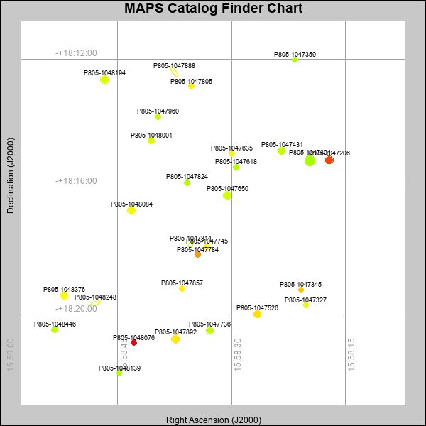 |
| Stars (point sources) are represented by filled circles. Galaxies (Extended objects) are represented by ellipses. The size of the object is an indication of its brightness (the O magnitude is printed next to each object). The color of the object indicates the actual color of the object. |
Your search returned 28 objects.
Download an ASCII text file of your results: /downloads/MAPS_output.2642471001.txt
MAPS Catalog Data for 28matching objects:
| IAU Name | raJ | declJ | magdo | magio | colord | colori | diao | thetaJO | ello | galnodo |
|---|---|---|---|---|---|---|---|---|---|---|
| MAPS-P805-1047304 | 15:58:19.686 | -18:15:10.61 | 14.44 | 17.33 | +1.34 | +1.62 | 15.72 | 47.75 | 0.250 | 0.010 |
| MAPS-P805-1047650 | 15:58:30.572 | -18:16:16.70 | 14.99 | 17.54 | +1.63 | +1.52 | 12.86 | 2.29 | 0.039 | 0.010 |
| MAPS-P805-1047892 | 15:58:37.396 | -18:20:45.86 | 15.06 | 17.55 | +2.08 | +1.81 | 12.72 | 41.59 | 0.037 | 0.010 |
| MAPS-P805-1047206 | 15:58:17.111 | -18:15:09.51 | 15.37 | 17.66 | +3.03 | +2.22 | 12.35 | 25.78 | 0.063 | 0.010 |
| MAPS-P805-1048194 | 15:58:46.718 | -18:12:39.15 | 15.37 | 17.70 | +1.69 | +1.63 | 13.14 | 51.71 | 0.172 | 0.010 |
| MAPS-P805-1047431 | 15:58:23.404 | -18:14:52.45 | 15.42 | 17.67 | +1.52 | +1.57 | 11.95 | 1.21 | 0.012 | 0.010 |
| MAPS-P805-1047888 | 15:58:37.557 | -18:12:24.20 | 15.44 | 17.92 | +1.92 | +1.84 | 20.39 | 37.00 | 0.662 | 1.000 |
| MAPS-P805-1048084 | 15:58:43.196 | -18:16:43.94 | 15.67 | 17.77 | +1.85 | +1.56 | 11.49 | 67.83 | 0.003 | 0.010 |
| MAPS-P805-1048248 | 15:58:47.938 | -18:19:38.57 | 16.03 | 18.12 | +1.78 | +1.74 | 18.41 | 108.65 | 0.648 | 1.000 |
| MAPS-P805-1047526 | 15:58:26.575 | -18:19:58.91 | 16.05 | 17.91 | +2.12 | +1.73 | 11.22 | 28.34 | 0.057 | 0.010 |
| MAPS-P805-1047736 | 15:58:32.871 | -18:20:30.24 | 16.18 | 17.89 | +1.48 | +1.58 | 11.06 | 175.21 | 0.064 | 0.010 |
| MAPS-P805-1048376 | 15:58:52.073 | -18:19:24.89 | 16.30 | 18.04 | +1.95 | +1.82 | 11.18 | 47.30 | 0.115 | 0.010 |
| MAPS-P805-1047814 | 15:58:35.369 | -18:17:48.04 | 17.37 | 18.64 | +1.54 | +1.68 | 11.04 | 145.07 | 0.337 | 0.670 |
| MAPS-P805-1047824 | 15:58:35.867 | -18:15:52.03 | 17.37 | 18.57 | +1.44 | +1.55 | 9.83 | 71.10 | 0.165 | 0.230 |
| MAPS-P805-1047635 | 15:58:29.989 | -18:14:57.54 | 17.43 | 18.48 | +1.81 | +1.63 | 9.39 | 78.92 | 0.100 | 0.010 |
| MAPS-P805-1047618 | 15:58:29.448 | -18:15:23.11 | 17.48 | 18.48 | +1.43 | +1.54 | 8.92 | 123.92 | 0.020 | 0.010 |
| MAPS-P805-1048001 | 15:58:40.618 | -18:14:33.47 | 17.59 | 18.59 | +1.69 | +1.74 | 9.83 | 59.85 | 0.219 | 0.010 |
| MAPS-P805-1048076 | 15:58:42.870 | -18:20:53.10 | 17.61 | 18.50 | +4.49 | +2.67 | 8.77 | 162.31 | 0.025 | 0.010 |
| MAPS-P805-1048446 | 15:58:53.317 | -18:20:27.95 | 17.62 | 18.67 | +1.52 | +1.73 | 9.49 | 142.67 | 0.172 | 0.040 |
| MAPS-P805-1047345 | 15:58:20.837 | -18:19:13.36 | 17.66 | 18.56 | +2.27 | +1.86 | 8.61 | 107.11 | 0.007 | 0.010 |
| MAPS-P805-1047745 | 15:58:33.240 | -18:17:52.32 | 17.70 | 18.68 | +1.98 | +1.91 | 9.25 | 108.24 | 0.149 | 0.040 |
| MAPS-P805-1047857 | 15:58:36.520 | -18:19:10.72 | 17.75 | 18.66 | +2.04 | +1.80 | 8.64 | 142.89 | 0.041 | 0.020 |
| MAPS-P805-1047960 | 15:58:39.694 | -18:13:48.28 | 17.75 | 18.60 | +1.57 | +1.62 | 8.77 | 88.52 | 0.070 | 0.010 |
| MAPS-P805-1047327 | 15:58:20.189 | -18:19:41.97 | 17.77 | 18.67 | +1.74 | +1.70 | 8.58 | 88.43 | 0.035 | 0.020 |
| MAPS-P805-1047805 | 15:58:35.279 | -18:12:51.70 | 17.80 | 18.59 | +2.01 | +1.90 | 8.80 | 24.92 | 0.093 | 0.010 |
| MAPS-P805-1047359 | 15:58:21.642 | -18:12:01.34 | 17.80 | 18.62 | +1.40 | +1.64 | 8.57 | 57.68 | 0.043 | 0.010 |
| MAPS-P805-1047784 | 15:58:34.485 | -18:18:07.54 | 17.82 | 18.71 | +2.55 | +1.82 | 8.98 | 156.50 | 0.134 | 0.040 |
| MAPS-P805-1048139 | 15:58:44.809 | -18:21:49.85 | 17.84 | 18.66 | +1.40 | +1.61 | 8.42 | 54.20 | 0.021 | 0.020 |
This page was generated at Fri, 26 Apr 2024 07:10:01 -0500 and took 5.782 seconds to serve.