Finder Charts
The queried region:
| Longitude/Right Ascension: | 14:49:21.6 | |
| Latitude/Declination: | 63.2705056 (degrees) | |
| Field Width: | 10.0 (arcminutes) | |
| Coordinate System: | J2000 |
|
MAPS Catalog Finder Chart Query Results
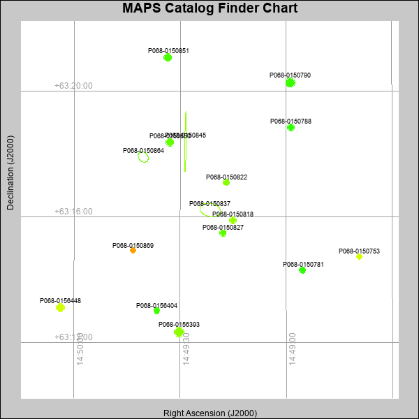 |
| Stars (point sources) are represented by filled circles. Galaxies (Extended objects) are represented by ellipses. The size of the object is an indication of its brightness (the O magnitude is printed next to each object). The color of the object indicates the actual color of the object. |
Your search returned 16 objects.
Download an ASCII text file of your results: /downloads/MAPS_output.2642473613.txt
MAPS Catalog Data for 16matching objects:
| IAU Name | raJ | declJ | magdo | magio | colord | colori | diao | thetaJO | ello | galnodo |
|---|---|---|---|---|---|---|---|---|---|---|
| MAPS-P068-0150837 | 14:49:21.519 | +63:16:13.72 | 10.33 | 15.71 | +0.84 | +1.18 | 40.15 | 78.87 | 0.382 | 0.820 |
| MAPS-P068-0150864 | 14:49:40.469 | +63:17:54.79 | 12.20 | 16.84 | +0.24 | +0.96 | 22.20 | 39.75 | 0.238 | 1.000 |
| MAPS-P068-0150845 | 14:49:28.486 | +63:18:24.62 | 12.81 | 17.54 | -1.80 | +1.21 | 115.68 | 179.07 | 0.977 | 1.000 |
| MAPS-P068-0156393 | 14:49:30.300 | +63:12:20.78 | 13.91 | 16.92 | +1.17 | +1.29 | 15.10 | 142.42 | 0.016 | 0.000 |
| MAPS-P068-0156448 | 14:50:03.786 | +63:13:07.09 | 14.88 | 17.29 | +1.61 | +1.41 | 13.19 | 96.87 | 0.016 | 0.010 |
| MAPS-P068-0150790 | 14:48:58.782 | +63:20:16.93 | 14.90 | 17.33 | +0.71 | +1.19 | 14.32 | 170.88 | 0.168 | 0.010 |
| MAPS-P068-0150850 | 14:49:32.960 | +63:18:22.74 | 15.16 | 17.37 | +0.91 | +1.19 | 12.61 | 44.66 | 0.004 | 0.010 |
| MAPS-P068-0150851 | 14:49:33.525 | +63:21:04.77 | 15.37 | 17.41 | +0.80 | +1.13 | 12.32 | 115.10 | 0.014 | 0.010 |
| MAPS-P068-0150788 | 14:48:58.680 | +63:18:51.24 | 16.42 | 17.84 | +0.66 | +1.07 | 10.73 | 82.68 | 0.048 | 0.010 |
| MAPS-P068-0150818 | 14:49:15.017 | +63:15:53.90 | 16.45 | 17.88 | +1.26 | +1.33 | 11.01 | 101.84 | 0.104 | 0.010 |
| MAPS-P068-0150827 | 14:49:17.887 | +63:15:29.55 | 16.61 | 17.93 | +0.90 | +1.19 | 10.26 | 110.07 | 0.017 | 0.010 |
| MAPS-P068-0150781 | 14:48:55.362 | +63:14:18.76 | 16.90 | 18.08 | +0.65 | +1.01 | 9.96 | 92.65 | 0.048 | 0.010 |
| MAPS-P068-0150822 | 14:49:16.905 | +63:17:06.27 | 17.24 | 18.23 | +1.14 | +1.23 | 9.44 | 96.02 | 0.052 | 0.010 |
| MAPS-P068-0156404 | 14:49:36.616 | +63:13:01.17 | 17.36 | 18.34 | +0.74 | +0.98 | 9.34 | 89.03 | 0.074 | 0.010 |
| MAPS-P068-0150753 | 14:48:39.371 | +63:14:44.46 | 17.61 | 18.45 | +1.63 | +1.24 | 8.78 | 76.33 | 0.039 | 0.010 |
| MAPS-P068-0150869 | 14:49:43.322 | +63:14:55.93 | 17.97 | 18.65 | +2.54 | +2.00 | 8.61 | 94.06 | 0.125 | 0.010 |
This page was generated at Fri, 26 Apr 2024 07:36:13 -0500 and took 0.224 seconds to serve.