Finder Charts
The queried region:
| Longitude/Right Ascension: | 00:33:45.8 | |
| Latitude/Declination: | -5.4797806 (degrees) | |
| Field Width: | 10.0 (arcminutes) | |
| Coordinate System: | J2000 |
|
MAPS Catalog Finder Chart Query Results
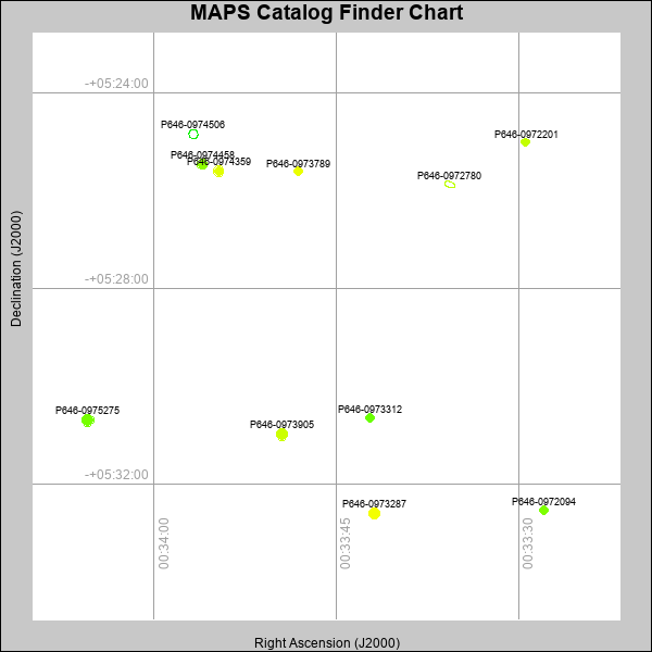 |
| Stars (point sources) are represented by filled circles. Galaxies (Extended objects) are represented by ellipses. The size of the object is an indication of its brightness (the O magnitude is printed next to each object). The color of the object indicates the actual color of the object. |
Your search returned 11 objects.
Download an ASCII text file of your results: /downloads/MAPS_output.26424182553.txt
MAPS Catalog Data for 11matching objects:
| IAU Name | raJ | declJ | magdo | magio | colord | colori | diao | thetaJO | ello | galnodo |
|---|---|---|---|---|---|---|---|---|---|---|
| MAPS-P646-0975275 | 00:34:05.422 | -05:30:42.31 | 14.89 | 17.61 | +1.04 | +1.54 | 12.24 | 5.71 | 0.014 | 0.010 |
| MAPS-P646-0973905 | 00:33:49.454 | -05:30:59.69 | 15.43 | 17.80 | +1.57 | +1.69 | 11.58 | 118.80 | 0.056 | 0.010 |
| MAPS-P646-0974506 | 00:33:56.739 | -05:24:51.06 | 15.46 | 18.48 | -0.78 | +0.48 | 11.71 | 19.22 | 0.085 | 0.990 |
| MAPS-P646-0973287 | 00:33:41.860 | -05:32:36.61 | 15.63 | 17.88 | +1.84 | +1.76 | 11.18 | 116.24 | 0.046 | 0.010 |
| MAPS-P646-0974458 | 00:33:55.990 | -05:25:28.31 | 16.26 | 18.12 | +1.18 | +1.52 | 10.24 | 34.43 | 0.057 | 0.010 |
| MAPS-P646-0974359 | 00:33:54.661 | -05:25:36.56 | 16.42 | 18.19 | +1.72 | +1.70 | 10.54 | 110.00 | 0.155 | 0.010 |
| MAPS-P646-0972780 | 00:33:35.665 | -05:25:52.99 | 16.52 | 18.75 | +0.98 | +1.47 | 13.42 | 70.14 | 0.495 | 0.990 |
| MAPS-P646-0972094 | 00:33:27.945 | -05:32:32.64 | 17.16 | 18.47 | +1.09 | +1.35 | 8.85 | 165.11 | 0.054 | 0.010 |
| MAPS-P646-0973789 | 00:33:48.115 | -05:25:36.63 | 17.41 | 18.61 | +1.79 | +1.75 | 8.56 | 135.77 | 0.070 | 0.010 |
| MAPS-P646-0973312 | 00:33:42.208 | -05:30:38.86 | 17.82 | 18.90 | +0.96 | +1.49 | 8.44 | 164.23 | 0.172 | 0.040 |
| MAPS-P646-0972201 | 00:33:29.465 | -05:25:00.82 | 17.87 | 18.76 | +1.52 | +1.63 | 7.96 | 91.08 | 0.089 | 0.010 |
This page was generated at Fri, 26 Apr 2024 18:25:53 -0500 and took 0.194 seconds to serve.