Finder Charts
The queried region:
| Longitude/Right Ascension: | 23:11:39.1 | |
| Latitude/Declination: | -6.2943091 (degrees) | |
| Field Width: | 10.0 (arcminutes) | |
| Coordinate System: | J2000 |
|
MAPS Catalog Finder Chart Query Results
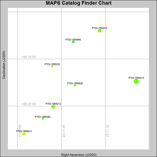 |
| Stars (point sources) are represented by filled circles. Galaxies (Extended objects) are represented by ellipses. The size of the object is an indication of its brightness (the O magnitude is printed next to each object). The color of the object indicates the actual color of the object. |
Your search returned 8 objects.
Download an ASCII text file of your results: /downloads/MAPS_output.2442475444.txt
MAPS Catalog Data for 8matching objects:
| IAU Name | raJ | declJ | magdo | magio | colord | colori | diao | thetaJO | ello | galnodo |
|---|---|---|---|---|---|---|---|---|---|---|
| MAPS-P703-1554013 | 23:11:19.393 | -06:17:53.47 | 12.25 | 16.77 | +1.03 | +1.50 | 20.46 | 7.94 | 0.019 | 0.010 |
| MAPS-P703-1555212 | 23:11:47.799 | -06:20:02.62 | 13.35 | 17.18 | +1.12 | +1.40 | 15.89 | 49.59 | 0.004 | 0.010 |
| MAPS-P703-1554572 | 23:11:31.961 | -06:13:35.73 | 14.25 | 17.55 | +1.06 | +1.49 | 13.94 | 72.23 | 0.032 | 0.010 |
| MAPS-P703-1555614 | 23:11:57.797 | -06:22:21.00 | 14.46 | 17.53 | +1.55 | +1.63 | 13.62 | 17.93 | 0.045 | 0.010 |
| MAPS-P703-1554946 | 23:11:40.952 | -06:14:31.80 | 17.11 | 18.45 | +0.55 | +1.31 | 9.70 | 17.13 | 0.089 | 0.010 |
| MAPS-P703-1555220 | 23:11:48.153 | -06:16:36.47 | 17.21 | 18.45 | +1.43 | +1.55 | 9.21 | 17.59 | 0.017 | 0.010 |
| MAPS-P703-1554928 | 23:11:40.351 | -06:18:13.62 | 17.85 | 18.67 | +1.01 | +1.20 | 9.04 | 24.93 | 0.160 | 0.010 |
| MAPS-P703-1555364 | 23:11:51.326 | -06:21:03.72 | 17.99 | 18.76 | +1.05 | +1.22 | 8.46 | 42.58 | 0.082 | 0.010 |
This page was generated at Wed, 24 Apr 2024 07:54:44 -0500 and took 0.150 seconds to serve.