Finder Charts
The queried region:
| Longitude/Right Ascension: | 22:31:59.9 | |
| Latitude/Declination: | -17.7324111 (degrees) | |
| Field Width: | 10.0 (arcminutes) | |
| Coordinate System: | J2000 |
|
MAPS Catalog Finder Chart Query Results
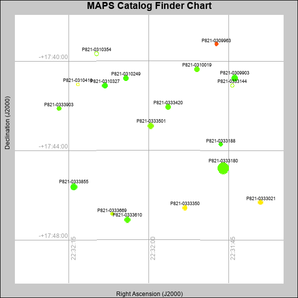 |
| Stars (point sources) are represented by filled circles. Galaxies (Extended objects) are represented by ellipses. The size of the object is an indication of its brightness (the O magnitude is printed next to each object). The color of the object indicates the actual color of the object. |
Your search returned 18 objects.
Download an ASCII text file of your results: /downloads/MAPS_output.19424153830.txt
MAPS Catalog Data for 18matching objects:
| IAU Name | raJ | declJ | magdo | magio | colord | colori | diao | thetaJO | ello | galnodo |
|---|---|---|---|---|---|---|---|---|---|---|
| MAPS-P821-0333180 | 22:31:45.969 | -17:44:47.94 | 11.74 | 16.19 | +0.93 | +1.90 | 24.61 | 179.23 | 0.402 | 0.000 |
| MAPS-P821-0309903 | 22:31:43.853 | -17:40:45.42 | 13.36 | 16.87 | +0.73 | +1.65 | 14.43 | 111.22 | 0.043 | 0.010 |
| MAPS-P821-0333855 | 22:32:14.051 | -17:45:37.67 | 13.40 | 16.85 | +0.73 | +1.62 | 14.49 | 126.59 | 0.064 | 0.010 |
| MAPS-P821-0333610 | 22:32:03.961 | -17:47:05.38 | 13.79 | 17.04 | +0.87 | +1.58 | 13.33 | 112.07 | 0.013 | 0.010 |
| MAPS-P821-0333501 | 22:31:59.629 | -17:42:53.72 | 14.04 | 17.08 | +1.17 | +1.86 | 12.99 | 153.35 | 0.035 | 0.010 |
| MAPS-P821-0310327 | 22:32:08.249 | -17:41:05.70 | 14.54 | 17.28 | +0.72 | +1.61 | 11.95 | 121.07 | 0.012 | 0.010 |
| MAPS-P821-0333420 | 22:31:56.360 | -17:42:02.83 | 14.85 | 17.41 | +0.91 | +1.70 | 11.46 | 176.98 | 0.014 | 0.010 |
| MAPS-P821-0310249 | 22:32:04.300 | -17:40:45.45 | 14.90 | 17.40 | +0.78 | +1.56 | 11.52 | 141.19 | 0.037 | 0.010 |
| MAPS-P821-0310354 | 22:32:09.798 | -17:39:40.05 | 15.24 | 18.02 | +0.30 | +1.18 | 11.13 | 32.34 | 0.063 | 1.000 |
| MAPS-P821-0310019 | 22:31:50.934 | -17:40:22.05 | 15.37 | 17.56 | +0.98 | +1.61 | 11.22 | 130.18 | 0.112 | 0.010 |
| MAPS-P821-0333350 | 22:31:53.214 | -17:46:33.76 | 15.45 | 17.62 | +2.03 | +2.04 | 10.84 | 146.27 | 0.071 | 0.010 |
| MAPS-P821-0333021 | 22:31:38.982 | -17:46:19.14 | 15.72 | 17.69 | +2.08 | +2.06 | 10.21 | 110.87 | 0.032 | 0.010 |
| MAPS-P821-0333144 | 22:31:44.292 | -17:41:05.69 | 16.30 | 18.19 | +0.65 | +1.29 | 9.46 | 157.28 | 0.052 | 0.770 |
| MAPS-P821-0333903 | 22:32:16.839 | -17:42:07.27 | 16.53 | 18.09 | +0.94 | +1.67 | 9.20 | 145.81 | 0.068 | 0.010 |
| MAPS-P821-0309963 | 22:31:47.265 | -17:39:14.07 | 16.99 | 18.23 | +2.95 | +2.30 | 8.67 | 154.01 | 0.093 | 0.020 |
| MAPS-P821-0333188 | 22:31:46.451 | -17:43:43.48 | 17.18 | 18.44 | +0.77 | +1.54 | 8.75 | 134.42 | 0.163 | 0.130 |
| MAPS-P821-0310416 | 22:32:13.297 | -17:41:02.74 | 17.40 | 18.73 | +1.51 | +1.79 | 8.19 | 89.17 | 0.116 | 0.980 |
| MAPS-P821-0333669 | 22:32:06.861 | -17:46:50.05 | 17.74 | 18.58 | +1.53 | +1.63 | 7.67 | 167.97 | 0.108 | 0.030 |
This page was generated at Fri, 19 Apr 2024 15:38:30 -0500 and took 0.225 seconds to serve.