Finder Charts
The queried region:
| Longitude/Right Ascension: | 16:24:03.5 | |
| Latitude/Declination: | -19.9459689 (degrees) | |
| Field Width: | 10.0 (arcminutes) | |
| Coordinate System: | J2000 |
|
MAPS Catalog Finder Chart Query Results
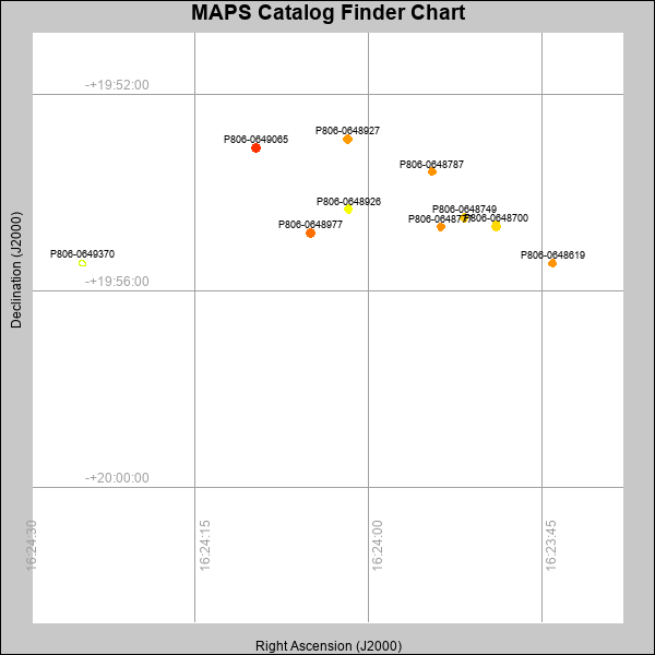 |
| Stars (point sources) are represented by filled circles. Galaxies (Extended objects) are represented by ellipses. The size of the object is an indication of its brightness (the O magnitude is printed next to each object). The color of the object indicates the actual color of the object. |
Your search returned 10 objects.
Download an ASCII text file of your results: /downloads/MAPS_output.25424162116.txt
MAPS Catalog Data for 10matching objects:
| IAU Name | raJ | declJ | magdo | magio | colord | colori | diao | thetaJO | ello | galnodo |
|---|---|---|---|---|---|---|---|---|---|---|
| MAPS-P806-0648700 | 16:23:48.944 | -19:54:40.83 | 16.97 | 18.25 | +2.17 | +1.68 | 9.24 | 5.83 | 0.034 | 0.010 |
| MAPS-P806-0648977 | 16:24:05.033 | -19:54:49.82 | 17.11 | 18.43 | +2.79 | +1.77 | 9.24 | 173.07 | 0.075 | 0.020 |
| MAPS-P806-0648619 | 16:23:44.057 | -19:55:26.17 | 17.44 | 18.56 | +2.59 | +1.95 | 8.59 | 126.63 | 0.037 | 0.020 |
| MAPS-P806-0649065 | 16:24:09.717 | -19:53:04.94 | 17.53 | 18.59 | +3.10 | +2.13 | 8.96 | 99.84 | 0.140 | 0.020 |
| MAPS-P806-0648777 | 16:23:53.726 | -19:54:41.91 | 17.64 | 18.57 | +2.61 | +1.93 | 8.20 | 106.54 | 0.010 | 0.010 |
| MAPS-P806-0648749 | 16:23:51.729 | -19:54:30.47 | 17.77 | 18.77 | +2.27 | +1.94 | 8.47 | 117.38 | 0.112 | 0.040 |
| MAPS-P806-0648787 | 16:23:54.497 | -19:53:34.60 | 17.82 | 18.64 | +2.59 | +1.91 | 8.10 | 83.60 | 0.048 | 0.010 |
| MAPS-P806-0648927 | 16:24:01.794 | -19:52:54.71 | 17.84 | 18.71 | +2.55 | +1.76 | 8.44 | 172.62 | 0.128 | 0.010 |
| MAPS-P806-0649370 | 16:24:24.783 | -19:55:26.43 | 17.91 | 18.90 | +1.81 | +1.62 | 9.15 | 67.52 | 0.277 | 0.610 |
| MAPS-P806-0648926 | 16:24:01.732 | -19:54:19.96 | 17.93 | 18.87 | +1.86 | +1.76 | 8.21 | 151.16 | 0.108 | 0.030 |
This page was generated at Thu, 25 Apr 2024 16:21:16 -0500 and took 5.075 seconds to serve.