Finder Charts
The queried region:
| Longitude/Right Ascension: | 15:46:02.2 | |
| Latitude/Declination: | -17.8533904 (degrees) | |
| Field Width: | 10.0 (arcminutes) | |
| Coordinate System: | J2000 |
|
MAPS Catalog Finder Chart Query Results
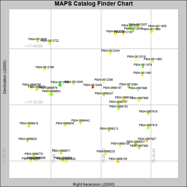 |
| Stars (point sources) are represented by filled circles. Galaxies (Extended objects) are represented by ellipses. The size of the object is an indication of its brightness (the O magnitude is printed next to each object). The color of the object indicates the actual color of the object. |
Your search returned 50 objects.
Download an ASCII text file of your results: /downloads/MAPS_output.19424165304.txt
MAPS Catalog Data for 50matching objects:
| IAU Name | raJ | declJ | magdo | magio | colord | colori | diao | thetaJO | ello | galnodo |
|---|---|---|---|---|---|---|---|---|---|---|
| MAPS-P804-0612019 | 15:45:49.424 | -17:48:45.73 | 13.85 | 16.98 | +1.21 | +1.55 | 19.74 | 51.90 | 0.517 | 0.990 |
| MAPS-P804-0668653 | 15:46:14.913 | -17:51:14.72 | 14.19 | 17.06 | +1.30 | +1.67 | 13.25 | 102.94 | 0.024 | 0.010 |
| MAPS-P804-0612071 | 15:45:51.210 | -17:46:31.81 | 15.10 | 17.32 | +1.25 | +1.56 | 11.76 | 91.98 | 0.048 | 0.010 |
| MAPS-P804-0668111 | 15:45:53.159 | -17:51:40.20 | 15.29 | 17.47 | +2.07 | +1.95 | 11.79 | 163.60 | 0.101 | 0.010 |
| MAPS-P804-0612663 | 15:46:12.318 | -17:50:34.93 | 15.52 | 17.53 | +0.41 | +1.25 | 11.07 | 111.77 | 0.048 | 0.010 |
| MAPS-P804-0668007 | 15:45:49.618 | -17:54:48.56 | 15.55 | 17.52 | +2.46 | +1.97 | 10.79 | 146.46 | 0.008 | 0.010 |
| MAPS-P804-0668818 | 15:46:21.667 | -17:53:30.38 | 15.92 | 17.65 | +1.71 | +1.74 | 10.38 | 112.03 | 0.041 | 0.010 |
| MAPS-P804-0612203 | 15:45:55.683 | -17:46:56.73 | 16.08 | 17.71 | +1.95 | +1.63 | 10.19 | 108.69 | 0.052 | 0.010 |
| MAPS-P804-0668155 | 15:45:54.915 | -17:56:02.28 | 16.33 | 17.80 | +2.33 | +1.90 | 9.82 | 138.31 | 0.057 | 0.010 |
| MAPS-P804-0612722 | 15:46:15.376 | -17:47:36.00 | 16.35 | 17.77 | +1.78 | +1.70 | 9.91 | 117.56 | 0.079 | 0.010 |
| MAPS-P804-0612007 | 15:45:48.946 | -17:46:27.19 | 16.43 | 17.86 | +1.98 | +1.79 | 9.67 | 7.39 | 0.057 | 0.010 |
| MAPS-P804-0668552 | 15:46:11.400 | -17:55:57.12 | 16.45 | 17.92 | +1.26 | +1.55 | 9.83 | 101.33 | 0.093 | 0.010 |
| MAPS-P804-0667915 | 15:45:45.824 | -17:53:38.24 | 16.58 | 17.91 | +1.61 | +1.61 | 10.07 | 108.64 | 0.173 | 0.010 |
| MAPS-P804-0668751 | 15:46:19.187 | -17:50:53.37 | 16.75 | 18.00 | +1.41 | +1.62 | 9.46 | 122.21 | 0.112 | 0.010 |
| MAPS-P804-0611900 | 15:45:44.900 | -17:46:47.23 | 16.79 | 18.02 | +1.63 | +1.67 | 9.32 | 87.13 | 0.097 | 0.020 |
| MAPS-P804-0668442 | 15:46:06.103 | -17:53:17.50 | 16.84 | 18.04 | +1.50 | +1.57 | 9.11 | 127.17 | 0.071 | 0.010 |
| MAPS-P804-0668796 | 15:46:20.808 | -17:50:44.37 | 16.86 | 18.08 | +2.23 | +1.98 | 9.11 | 80.26 | 0.075 | 0.010 |
| MAPS-P804-0667985 | 15:45:48.555 | -17:51:41.17 | 16.92 | 18.05 | +1.88 | +1.68 | 8.95 | 102.16 | 0.064 | 0.010 |
| MAPS-P804-0668187 | 15:45:56.588 | -17:50:59.16 | 16.92 | 18.21 | +1.58 | +1.72 | 9.64 | 95.66 | 0.194 | 0.940 |
| MAPS-P804-0612244 | 15:45:57.158 | -17:48:18.89 | 16.94 | 18.07 | +1.86 | +1.78 | 9.01 | 131.11 | 0.082 | 0.010 |
| MAPS-P804-0668213 | 15:45:57.639 | -17:53:50.91 | 17.01 | 18.11 | +1.49 | +1.56 | 8.57 | 121.33 | 0.008 | 0.010 |
| MAPS-P804-0668571 | 15:46:11.981 | -17:55:26.85 | 17.11 | 18.17 | +1.32 | +1.51 | 8.75 | 101.13 | 0.082 | 0.010 |
| MAPS-P804-0668676 | 15:46:15.802 | -17:50:56.65 | 17.15 | 18.15 | +1.65 | +1.65 | 8.62 | 72.54 | 0.067 | 0.010 |
| MAPS-P804-0668233 | 15:45:58.559 | -17:55:29.29 | 17.17 | 18.13 | +1.90 | +1.70 | 8.71 | 114.06 | 0.090 | 0.010 |
| MAPS-P804-0667982 | 15:45:48.594 | -17:55:04.76 | 17.17 | 18.28 | +1.32 | +1.47 | 8.65 | 111.74 | 0.079 | 0.080 |
| MAPS-P804-0612298 | 15:45:59.178 | -17:50:24.07 | 17.27 | 18.39 | +2.79 | +2.12 | 8.74 | 138.45 | 0.129 | 0.740 |
| MAPS-P804-0611981 | 15:45:47.592 | -17:49:53.17 | 17.30 | 18.24 | +1.66 | +1.61 | 8.51 | 123.77 | 0.093 | 0.220 |
| MAPS-P804-0668136 | 15:45:54.217 | -17:54:55.39 | 17.32 | 18.19 | +1.79 | +1.55 | 8.61 | 106.47 | 0.119 | 0.010 |
| MAPS-P804-0611882 | 15:45:44.493 | -17:48:54.34 | 17.34 | 18.26 | +2.00 | +1.78 | 8.23 | 107.94 | 0.043 | 0.080 |
| MAPS-P804-0612045 | 15:45:50.323 | -17:46:43.34 | 17.36 | 18.28 | +1.25 | +1.41 | 8.38 | 111.04 | 0.082 | 0.330 |
| MAPS-P804-0668528 | 15:46:10.416 | -17:56:01.47 | 17.39 | 18.26 | +2.05 | +1.55 | 8.62 | 116.03 | 0.143 | 0.010 |
| MAPS-P804-0668770 | 15:46:20.136 | -17:55:39.73 | 17.39 | 18.29 | +1.37 | +1.48 | 8.10 | 124.76 | 0.029 | 0.050 |
| MAPS-P804-0668157 | 15:45:54.825 | -17:51:55.96 | 17.43 | 18.32 | +1.41 | +1.55 | 8.16 | 161.89 | 0.056 | 0.130 |
| MAPS-P804-0611855 | 15:45:43.173 | -17:46:33.01 | 17.45 | 18.30 | +1.27 | +1.41 | 8.39 | 82.02 | 0.112 | 0.130 |
| MAPS-P804-0612130 | 15:45:53.303 | -17:46:57.74 | 17.46 | 18.32 | +2.06 | +1.80 | 8.09 | 87.62 | 0.052 | 0.340 |
| MAPS-P804-0668545 | 15:46:10.796 | -17:53:27.90 | 17.50 | 18.35 | +1.77 | +1.68 | 8.10 | 163.73 | 0.067 | 0.210 |
| MAPS-P804-0668247 | 15:45:59.124 | -17:51:20.00 | 17.53 | 18.36 | +1.43 | +1.55 | 7.81 | 43.17 | 0.008 | 0.010 |
| MAPS-P804-0612766 | 15:46:16.859 | -17:49:27.97 | 17.55 | 18.35 | +1.79 | +1.73 | 7.89 | 133.08 | 0.034 | 0.080 |
| MAPS-P804-0668152 | 15:45:54.690 | -17:52:16.71 | 17.60 | 18.48 | +1.43 | +1.59 | 8.01 | 119.32 | 0.082 | 0.290 |
| MAPS-P804-0668797 | 15:46:21.019 | -17:55:59.34 | 17.64 | 18.38 | +1.70 | +1.62 | 8.24 | 138.60 | 0.143 | 0.020 |
| MAPS-P804-0667927 | 15:45:46.251 | -17:54:35.82 | 17.66 | 18.42 | +2.31 | +1.97 | 8.11 | 85.83 | 0.122 | 0.150 |
| MAPS-P804-0668825 | 15:46:22.029 | -17:54:34.70 | 17.66 | 18.45 | +2.22 | +1.90 | 7.74 | 14.37 | 0.035 | 0.170 |
| MAPS-P804-0612826 | 15:46:18.990 | -17:47:28.74 | 17.66 | 18.36 | +1.62 | +1.45 | 7.97 | 112.25 | 0.090 | 0.100 |
| MAPS-P804-0667918 | 15:45:45.850 | -17:52:37.30 | 17.69 | 18.40 | +1.15 | +1.33 | 7.80 | 157.54 | 0.064 | 0.020 |
| MAPS-P804-0612404 | 15:46:02.440 | -17:50:44.15 | 17.71 | 18.50 | +3.17 | +2.42 | 7.92 | 112.45 | 0.097 | 0.020 |
| MAPS-P804-0668755 | 15:46:19.429 | -17:55:56.04 | 17.73 | 18.44 | +1.42 | +1.47 | 7.60 | 176.45 | 0.026 | 0.090 |
| MAPS-P804-0612545 | 15:46:08.190 | -17:50:30.52 | 17.76 | 18.54 | +1.71 | +1.74 | 7.78 | 78.13 | 0.082 | 0.030 |
| MAPS-P804-0612084 | 15:45:51.699 | -17:50:42.16 | 17.78 | 18.58 | +0.99 | +1.39 | 7.70 | 128.82 | 0.071 | 0.040 |
| MAPS-P804-0611974 | 15:45:47.433 | -17:49:17.46 | 17.80 | 18.47 | +1.06 | +1.08 | 7.90 | 83.85 | 0.123 | 0.020 |
| MAPS-P804-0667996 | 15:45:48.926 | -17:50:59.56 | 17.83 | 19.37 | +1.18 | +1.11 | 11.02 | 23.40 | 0.555 | 0.990 |
This page was generated at Fri, 19 Apr 2024 16:53:04 -0500 and took 0.499 seconds to serve.