Finder Charts
The queried region:
| Longitude/Right Ascension: | 15:37:31.2 | |
| Latitude/Declination: | -17.4417596 (degrees) | |
| Field Width: | 10.0 (arcminutes) | |
| Coordinate System: | J2000 |
|
MAPS Catalog Finder Chart Query Results
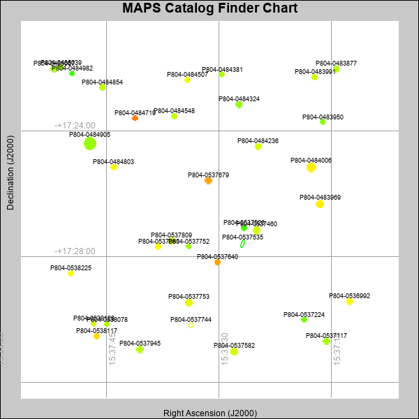 |
| Stars (point sources) are represented by filled circles. Galaxies (Extended objects) are represented by ellipses. The size of the object is an indication of its brightness (the O magnitude is printed next to each object). The color of the object indicates the actual color of the object. |
Your search returned 36 objects.
Download an ASCII text file of your results: /downloads/MAPS_output.19424110932.txt
MAPS Catalog Data for 36matching objects:
| IAU Name | raJ | declJ | magdo | magio | colord | colori | diao | thetaJO | ello | galnodo |
|---|---|---|---|---|---|---|---|---|---|---|
| MAPS-P804-0484905 | 15:37:47.203 | -17:24:23.62 | 11.83 | 16.32 | +1.25 | +1.73 | 19.03 | 91.41 | 0.032 | 0.000 |
| MAPS-P804-0484006 | 15:37:17.666 | -17:25:09.20 | 13.70 | 16.89 | +2.02 | +1.95 | 14.32 | 51.03 | 0.041 | 0.000 |
| MAPS-P804-0537460 | 15:37:24.957 | -17:27:09.37 | 15.06 | 17.36 | +1.60 | +1.74 | 11.90 | 76.22 | 0.057 | 0.010 |
| MAPS-P804-0483969 | 15:37:16.509 | -17:26:19.09 | 15.21 | 17.41 | +2.05 | +1.99 | 11.62 | 100.58 | 0.054 | 0.010 |
| MAPS-P804-0537753 | 15:37:34.017 | -17:29:27.52 | 15.44 | 17.50 | +1.75 | +1.82 | 11.61 | 91.10 | 0.115 | 0.010 |
| MAPS-P804-0537945 | 15:37:40.490 | -17:30:57.25 | 15.61 | 17.54 | +1.44 | +1.67 | 10.96 | 111.92 | 0.057 | 0.010 |
| MAPS-P804-0537582 | 15:37:27.929 | -17:31:00.84 | 15.72 | 17.58 | +1.63 | +1.72 | 11.18 | 97.70 | 0.123 | 0.010 |
| MAPS-P804-0484324 | 15:37:27.320 | -17:23:09.46 | 15.95 | 17.71 | +1.18 | +1.56 | 10.31 | 78.30 | 0.037 | 0.010 |
| MAPS-P804-0537679 | 15:37:31.409 | -17:25:34.74 | 15.97 | 17.71 | +2.51 | +2.05 | 10.64 | 97.33 | 0.101 | 0.010 |
| MAPS-P804-0537117 | 15:37:15.638 | -17:30:41.10 | 15.97 | 17.70 | +1.34 | +1.60 | 10.36 | 73.20 | 0.050 | 0.010 |
| MAPS-P804-0485067 | 15:37:52.013 | -17:22:01.18 | 16.02 | 17.71 | +1.33 | +1.59 | 10.33 | 104.99 | 0.059 | 0.010 |
| MAPS-P804-0536992 | 15:37:12.540 | -17:29:25.43 | 16.07 | 17.74 | +1.90 | +1.85 | 10.02 | 65.95 | 0.016 | 0.010 |
| MAPS-P804-0537809 | 15:37:36.293 | -17:27:29.60 | 16.15 | 17.77 | +1.66 | +1.79 | 10.02 | 91.86 | 0.041 | 0.010 |
| MAPS-P804-0537535 | 15:37:26.794 | -17:27:34.45 | 16.36 | 18.63 | -0.27 | +0.35 | 15.99 | 156.68 | 0.648 | 0.990 |
| MAPS-P804-0484236 | 15:37:24.739 | -17:24:29.51 | 16.50 | 17.90 | +1.65 | +1.72 | 9.92 | 70.42 | 0.123 | 0.010 |
| MAPS-P804-0484803 | 15:37:44.034 | -17:25:08.95 | 16.60 | 17.95 | +1.84 | +1.83 | 9.63 | 125.31 | 0.100 | 0.010 |
| MAPS-P804-0483991 | 15:37:17.241 | -17:22:16.47 | 16.63 | 17.93 | +1.56 | +1.62 | 9.15 | 108.85 | 0.014 | 0.010 |
| MAPS-P804-0483877 | 15:37:14.335 | -17:22:01.53 | 16.65 | 17.95 | +1.43 | +1.57 | 9.65 | 70.50 | 0.119 | 0.010 |
| MAPS-P804-0537640 | 15:37:30.151 | -17:28:10.63 | 16.68 | 17.95 | +2.51 | +2.08 | 9.30 | 82.63 | 0.061 | 0.010 |
| MAPS-P804-0484854 | 15:37:45.543 | -17:22:36.55 | 16.70 | 17.97 | +1.50 | +1.61 | 9.38 | 85.16 | 0.082 | 0.010 |
| MAPS-P804-0538117 | 15:37:46.315 | -17:30:31.27 | 16.75 | 18.02 | +2.17 | +1.94 | 9.38 | 95.39 | 0.097 | 0.010 |
| MAPS-P804-0537526 | 15:37:26.665 | -17:27:05.02 | 16.75 | 17.99 | +0.78 | +1.31 | 9.09 | 17.51 | 0.039 | 0.010 |
| MAPS-P804-0537861 | 15:37:38.115 | -17:27:40.35 | 16.80 | 18.08 | +1.91 | +1.83 | 9.13 | 91.87 | 0.063 | 0.040 |
| MAPS-P804-0537744 | 15:37:33.708 | -17:30:10.79 | 16.84 | 18.16 | +1.59 | +1.81 | 10.40 | 138.32 | 0.287 | 0.990 |
| MAPS-P804-0484548 | 15:37:35.970 | -17:23:31.13 | 16.99 | 18.15 | +1.49 | +1.68 | 9.10 | 111.08 | 0.115 | 0.030 |
| MAPS-P804-0485039 | 15:37:51.004 | -17:21:58.69 | 16.99 | 18.09 | +1.30 | +1.55 | 8.82 | 74.61 | 0.059 | 0.010 |
| MAPS-P804-0538128 | 15:37:46.700 | -17:30:07.39 | 17.17 | 18.18 | +1.63 | +1.67 | 8.36 | 7.10 | 0.012 | 0.010 |
| MAPS-P804-0484381 | 15:37:29.603 | -17:22:12.10 | 17.20 | 18.30 | +1.39 | +1.68 | 8.70 | 93.32 | 0.100 | 0.050 |
| MAPS-P804-0484719 | 15:37:41.175 | -17:23:35.01 | 17.30 | 18.33 | +2.72 | +2.02 | 8.55 | 159.81 | 0.101 | 0.040 |
| MAPS-P804-0484507 | 15:37:34.171 | -17:22:22.16 | 17.34 | 18.28 | +1.81 | +1.74 | 8.53 | 128.49 | 0.108 | 0.020 |
| MAPS-P804-0538225 | 15:37:49.745 | -17:28:31.40 | 17.36 | 18.25 | +1.87 | +1.77 | 8.48 | 122.07 | 0.104 | 0.010 |
| MAPS-P804-0483950 | 15:37:16.147 | -17:23:42.29 | 17.41 | 18.34 | +1.10 | +1.40 | 8.27 | 77.14 | 0.074 | 0.030 |
| MAPS-P804-0484982 | 15:37:49.565 | -17:22:09.63 | 17.48 | 18.37 | +0.76 | +1.09 | 8.16 | 34.33 | 0.075 | 0.030 |
| MAPS-P804-0537224 | 15:37:18.638 | -17:30:00.07 | 17.57 | 18.46 | +1.00 | +1.35 | 8.42 | 94.42 | 0.158 | 0.200 |
| MAPS-P804-0538078 | 15:37:44.941 | -17:30:08.63 | 17.76 | 18.49 | +1.42 | +1.62 | 7.81 | 100.83 | 0.090 | 0.090 |
| MAPS-P804-0537752 | 15:37:34.013 | -17:27:39.85 | 17.85 | 18.51 | +1.27 | +1.49 | 8.02 | 85.63 | 0.165 | 0.100 |
This page was generated at Fri, 19 Apr 2024 11:09:32 -0500 and took 3.524 seconds to serve.