Finder Charts
The queried region:
| Longitude/Right Ascension: | 14:55:53.9 | |
| Latitude/Declination: | -10.0168861 (degrees) | |
| Field Width: | 10.0 (arcminutes) | |
| Coordinate System: | J2000 |
|
MAPS Catalog Finder Chart Query Results
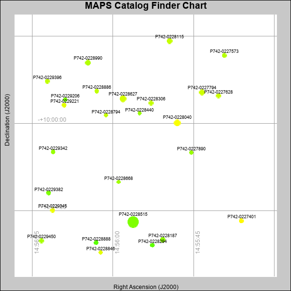 |
| Stars (point sources) are represented by filled circles. Galaxies (Extended objects) are represented by ellipses. The size of the object is an indication of its brightness (the O magnitude is printed next to each object). The color of the object indicates the actual color of the object. |
Your search returned 26 objects.
Download an ASCII text file of your results: /downloads/MAPS_output.23424193619.txt
MAPS Catalog Data for 26matching objects:
| IAU Name | raJ | declJ | magdo | magio | colord | colori | diao | thetaJO | ello | galnodo |
|---|---|---|---|---|---|---|---|---|---|---|
| MAPS-P742-0228515 | 14:55:56.254 | -10:04:30.64 | 11.39 | 16.14 | +1.09 | +1.72 | 25.20 | 21.60 | 0.046 | 0.000 |
| MAPS-P742-0228040 | 14:55:48.004 | -09:59:57.47 | 13.57 | 17.05 | +1.88 | +2.11 | 15.33 | 25.71 | 0.039 | 0.010 |
| MAPS-P742-0228627 | 14:55:58.133 | -09:58:51.69 | 14.15 | 17.34 | +1.64 | +2.05 | 14.39 | 15.97 | 0.092 | 0.010 |
| MAPS-P742-0227794 | 14:55:43.405 | -09:58:34.35 | 15.00 | 17.53 | +1.61 | +1.94 | 12.90 | 164.71 | 0.112 | 0.000 |
| MAPS-P742-0228115 | 14:55:49.455 | -09:56:13.18 | 15.13 | 17.58 | +1.54 | +1.86 | 12.27 | 10.09 | 0.054 | 0.010 |
| MAPS-P742-0228990 | 14:56:04.669 | -09:57:12.29 | 15.15 | 17.60 | +1.42 | +1.85 | 12.40 | 7.74 | 0.078 | 0.010 |
| MAPS-P742-0228187 | 14:55:50.745 | -10:05:19.42 | 15.47 | 17.69 | +1.18 | +1.73 | 11.75 | 3.43 | 0.059 | 0.010 |
| MAPS-P742-0228306 | 14:55:52.941 | -09:59:03.71 | 16.03 | 17.87 | +1.52 | +1.89 | 10.99 | 176.23 | 0.079 | 0.010 |
| MAPS-P742-0229450 | 14:56:13.338 | -10:05:22.19 | 16.05 | 17.90 | +1.35 | +1.76 | 10.97 | 20.86 | 0.081 | 0.010 |
| MAPS-P742-0227628 | 14:55:40.342 | -09:58:43.88 | 16.21 | 17.99 | +1.58 | +1.76 | 10.62 | 10.51 | 0.061 | 0.010 |
| MAPS-P742-0229345 | 14:56:11.277 | -10:03:58.19 | 16.32 | 17.95 | +1.80 | +1.78 | 10.70 | 20.82 | 0.101 | 0.010 |
| MAPS-P742-0227573 | 14:55:39.238 | -09:56:52.15 | 16.32 | 18.03 | +1.44 | +1.77 | 10.78 | 175.68 | 0.115 | 0.010 |
| MAPS-P742-0229396 | 14:56:12.182 | -09:58:03.86 | 16.49 | 18.07 | +1.49 | +1.82 | 10.04 | 16.54 | 0.029 | 0.010 |
| MAPS-P742-0227401 | 14:55:36.090 | -10:04:26.82 | 16.51 | 18.19 | +1.98 | +2.06 | 10.13 | 53.24 | 0.052 | 0.030 |
| MAPS-P742-0229221 | 14:56:09.065 | -09:59:09.21 | 16.73 | 18.20 | +1.75 | +1.74 | 9.98 | 23.49 | 0.082 | 0.010 |
| MAPS-P742-0229342 | 14:56:11.140 | -10:01:17.77 | 16.76 | 18.18 | +1.25 | +1.64 | 9.76 | 6.92 | 0.050 | 0.010 |
| MAPS-P742-0228888 | 14:56:03.122 | -10:05:27.11 | 16.93 | 18.35 | +0.88 | +1.54 | 9.75 | 22.95 | 0.093 | 0.040 |
| MAPS-P742-0228886 | 14:56:03.011 | -09:58:30.66 | 16.98 | 18.28 | +1.49 | +1.81 | 9.57 | 71.51 | 0.074 | 0.010 |
| MAPS-P742-0228294 | 14:55:52.667 | -10:05:33.93 | 17.02 | 18.38 | +0.91 | +1.56 | 9.38 | 111.72 | 0.046 | 0.040 |
| MAPS-P742-0229382 | 14:56:11.994 | -10:03:10.69 | 17.22 | 18.41 | +1.08 | +1.51 | 9.41 | 7.67 | 0.108 | 0.020 |
| MAPS-P742-0229206 | 14:56:08.867 | -09:58:54.14 | 17.22 | 18.38 | +1.04 | +1.61 | 9.35 | 14.00 | 0.097 | 0.010 |
| MAPS-P742-0228846 | 14:56:02.292 | -10:05:54.18 | 17.43 | 18.44 | +1.74 | +1.80 | 8.73 | 9.84 | 0.027 | 0.010 |
| MAPS-P742-0227890 | 14:55:45.385 | -10:01:19.59 | 17.44 | 18.53 | +1.25 | +1.69 | 9.08 | 62.64 | 0.107 | 0.040 |
| MAPS-P742-0228794 | 14:56:01.293 | -09:59:36.88 | 17.72 | 18.59 | +1.51 | +1.71 | 8.54 | 60.24 | 0.078 | 0.010 |
| MAPS-P742-0228668 | 14:55:58.963 | -10:02:40.24 | 17.82 | 18.66 | +1.30 | +1.67 | 8.27 | 11.05 | 0.045 | 0.200 |
| MAPS-P742-0228440 | 14:55:55.039 | -09:59:31.71 | 17.95 | 18.72 | +1.25 | +1.64 | 8.44 | 17.10 | 0.123 | 0.050 |
This page was generated at Tue, 23 Apr 2024 19:36:19 -0500 and took 2.891 seconds to serve.