Finder Charts
The queried region:
| Longitude/Right Ascension: | 13:29:52.7 | |
| Latitude/Declination: | 47.1952583 (degrees) | |
| Field Width: | 10.0 (arcminutes) | |
| Coordinate System: | J2000 |
|
MAPS Catalog Finder Chart Query Results
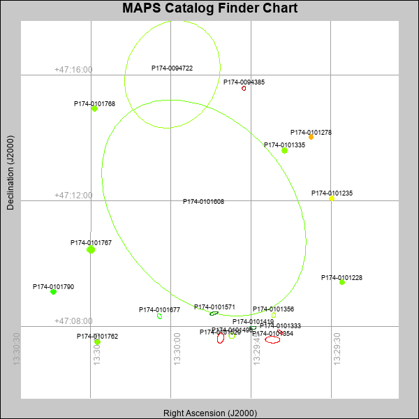 |
| Stars (point sources) are represented by filled circles. Galaxies (Extended objects) are represented by ellipses. The size of the object is an indication of its brightness (the O magnitude is printed next to each object). The color of the object indicates the actual color of the object. |
Your search returned 19 objects.
Download an ASCII text file of your results: /downloads/MAPS_output.2042465054.txt
MAPS Catalog Data for 19matching objects:
| IAU Name | raJ | declJ | magdo | magio | colord | colori | diao | thetaJO | ello | galnodo |
|---|---|---|---|---|---|---|---|---|---|---|
| MAPS-P174-0094722 | 13:29:59.722 | +47:16:01.80 | 5.75 | 11.51 | -0.67 | +1.23 | 209.72 | 157.03 | 0.157 | 1.000 |
| MAPS-P174-0101608 | 13:29:53.818 | +47:11:46.53 | 5.75 | 9.78 | -0.67 | +0.97 | 462.00 | 39.99 | 0.287 | 1.000 |
| MAPS-P174-0101354 | 13:29:40.949 | +47:07:34.91 | 11.97 | 17.35 | -7.82 | -3.43 | 28.09 | 88.17 | 0.559 | 1.000 |
| MAPS-P174-0101529 | 13:29:50.700 | +47:07:38.02 | 12.86 | 17.70 | -6.60 | -2.82 | 19.82 | 168.46 | 0.388 | 1.000 |
| MAPS-P174-0101767 | 13:30:14.979 | +47:10:27.38 | 14.54 | 16.97 | +1.10 | +1.39 | 11.99 | 99.25 | 0.043 | 0.010 |
| MAPS-P174-0101496 | 13:29:48.573 | +47:07:42.43 | 15.13 | 17.45 | +0.74 | +1.25 | 11.04 | 112.66 | 0.057 | 0.980 |
| MAPS-P174-0101571 | 13:29:51.944 | +47:08:25.38 | 15.93 | 18.77 | -1.85 | -0.28 | 15.97 | 105.69 | 0.647 | 0.990 |
| MAPS-P174-0101335 | 13:29:38.690 | +47:13:36.32 | 16.36 | 17.73 | +1.20 | +1.37 | 8.89 | 113.67 | 0.008 | 0.010 |
| MAPS-P174-0101419 | 13:29:44.635 | +47:07:57.73 | 16.49 | 18.75 | -1.94 | -0.75 | 12.39 | 93.45 | 0.509 | 0.990 |
| MAPS-P174-0101790 | 13:30:21.954 | +47:09:06.03 | 16.60 | 17.87 | +0.67 | +1.03 | 8.80 | 87.86 | 0.059 | 0.030 |
| MAPS-P174-0101762 | 13:30:13.781 | +47:07:30.67 | 16.69 | 17.87 | +1.16 | +1.36 | 8.76 | 59.00 | 0.079 | 0.010 |
| MAPS-P174-0101356 | 13:29:40.772 | +47:08:21.70 | 16.83 | 19.09 | +2.45 | +1.36 | 9.35 | 168.71 | 0.230 | 0.990 |
| MAPS-P174-0101677 | 13:30:02.141 | +47:08:19.96 | 16.83 | 19.02 | +0.13 | +0.59 | 10.19 | 30.66 | 0.351 | 0.990 |
| MAPS-P174-0101768 | 13:30:14.308 | +47:14:56.19 | 17.02 | 18.04 | +1.18 | +0.86 | 8.15 | 134.83 | 0.048 | 0.020 |
| MAPS-P174-0101235 | 13:29:29.868 | +47:12:04.57 | 17.03 | 17.92 | +1.82 | +1.52 | 8.20 | 76.91 | 0.064 | 0.010 |
| MAPS-P174-0101228 | 13:29:27.936 | +47:09:24.21 | 17.07 | 17.97 | +1.11 | +1.31 | 7.95 | 126.27 | 0.017 | 0.010 |
| MAPS-P174-0101333 | 13:29:39.521 | +47:07:49.40 | 17.09 | 19.24 | -2.90 | -2.02 | 13.69 | 55.46 | 0.671 | 0.990 |
| MAPS-P174-0101278 | 13:29:33.713 | +47:14:02.10 | 17.83 | 18.50 | +2.43 | +1.89 | 7.19 | 108.07 | 0.086 | 0.040 |
| MAPS-P174-0094385 | 13:29:46.324 | +47:15:34.81 | 17.91 | 19.71 | -2.16 | -1.90 | 7.47 | 174.91 | 0.178 | 0.990 |
This page was generated at Sat, 20 Apr 2024 06:50:54 -0500 and took 0.321 seconds to serve.