Finder Charts
The queried region:
| Longitude/Right Ascension: | 13:15:35.9 | |
| Latitude/Declination: | -2.3740528 (degrees) | |
| Field Width: | 10.0 (arcminutes) | |
| Coordinate System: | J2000 |
|
MAPS Catalog Finder Chart Query Results
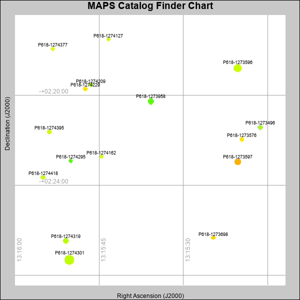 |
| Stars (point sources) are represented by filled circles. Galaxies (Extended objects) are represented by ellipses. The size of the object is an indication of its brightness (the O magnitude is printed next to each object). The color of the object indicates the actual color of the object. |
Your search returned 16 objects.
Download an ASCII text file of your results: /downloads/MAPS_output.1642463600.txt
MAPS Catalog Data for 16matching objects:
| IAU Name | raJ | declJ | magdo | magio | colord | colori | diao | thetaJO | ello | galnodo |
|---|---|---|---|---|---|---|---|---|---|---|
| MAPS-P618-1274301 | 13:15:50.291 | -02:27:18.57 | 11.64 | 16.40 | +1.48 | +1.72 | 20.53 | 35.08 | 0.024 | 0.010 |
| MAPS-P618-1273596 | 13:15:20.356 | -02:18:47.44 | 12.89 | 16.81 | +1.55 | +1.51 | 16.22 | 178.46 | 0.008 | 0.000 |
| MAPS-P618-1273597 | 13:15:20.319 | -02:22:57.03 | 14.01 | 17.18 | +2.42 | +1.79 | 13.84 | 175.60 | 0.035 | 0.010 |
| MAPS-P618-1273958 | 13:15:35.770 | -02:20:15.97 | 14.56 | 17.44 | +0.85 | +1.38 | 13.17 | 12.27 | 0.098 | 0.010 |
| MAPS-P618-1274319 | 13:15:50.921 | -02:26:28.16 | 15.49 | 17.66 | +1.46 | +1.50 | 11.36 | 2.36 | 0.079 | 0.010 |
| MAPS-P618-1273496 | 13:15:16.345 | -02:21:25.30 | 15.68 | 17.80 | +1.34 | +1.46 | 11.06 | 149.79 | 0.083 | 0.010 |
| MAPS-P618-1274229 | 13:15:47.453 | -02:19:42.64 | 16.65 | 18.09 | +2.12 | +1.65 | 9.62 | 4.77 | 0.103 | 0.010 |
| MAPS-P618-1274418 | 13:15:54.980 | -02:23:38.24 | 16.84 | 18.21 | +1.56 | +1.55 | 9.41 | 161.15 | 0.118 | 0.010 |
| MAPS-P618-1274395 | 13:15:53.845 | -02:21:37.29 | 16.89 | 18.22 | +1.56 | +1.50 | 9.03 | 159.27 | 0.059 | 0.010 |
| MAPS-P618-1273576 | 13:15:19.611 | -02:21:57.29 | 17.19 | 18.36 | +2.09 | +1.71 | 8.64 | 172.50 | 0.070 | 0.020 |
| MAPS-P618-1274377 | 13:15:53.233 | -02:17:55.49 | 17.19 | 18.35 | +1.75 | +1.54 | 8.61 | 160.71 | 0.063 | 0.020 |
| MAPS-P618-1274209 | 13:15:46.475 | -02:19:32.04 | 17.26 | 18.36 | +1.40 | +1.48 | 8.58 | 123.76 | 0.079 | 0.020 |
| MAPS-P618-1274295 | 13:15:50.070 | -02:22:54.32 | 17.32 | 18.44 | +0.83 | +1.27 | 8.36 | 170.47 | 0.048 | 0.050 |
| MAPS-P618-1273698 | 13:15:24.693 | -02:26:19.56 | 17.52 | 18.46 | +2.21 | +1.78 | 7.96 | 166.97 | 0.021 | 0.050 |
| MAPS-P618-1274127 | 13:15:43.356 | -02:17:30.13 | 17.61 | 18.55 | +1.58 | +1.52 | 7.80 | 101.70 | 0.013 | 0.100 |
| MAPS-P618-1274162 | 13:15:44.585 | -02:22:42.92 | 17.85 | 18.65 | +1.57 | +1.55 | 7.65 | 153.50 | 0.059 | 0.080 |
This page was generated at Tue, 16 Apr 2024 06:36:00 -0500 and took 0.162 seconds to serve.