Finder Charts
The queried region:
| Longitude/Right Ascension: | 02:27:22.6 | |
| Latitude/Declination: | 1.8274278 (degrees) | |
| Field Width: | 10.0 (arcminutes) | |
| Coordinate System: | J2000 |
|
MAPS Catalog Finder Chart Query Results
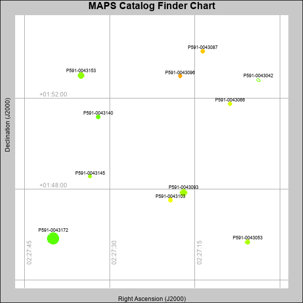 |
| Stars (point sources) are represented by filled circles. Galaxies (Extended objects) are represented by ellipses. The size of the object is an indication of its brightness (the O magnitude is printed next to each object). The color of the object indicates the actual color of the object. |
Your search returned 11 objects.
Download an ASCII text file of your results: /downloads/MAPS_output.2042412327.txt
MAPS Catalog Data for 11matching objects:
| IAU Name | raJ | declJ | magdo | magio | colord | colori | diao | thetaJO | ello | galnodo |
|---|---|---|---|---|---|---|---|---|---|---|
| MAPS-P591-0043172 | 02:27:39.969 | +01:45:49.87 | 10.97 | 15.86 | +0.88 | +1.40 | 26.07 | 71.91 | 0.019 | 0.060 |
| MAPS-P591-0043093 | 02:27:16.985 | +01:47:50.92 | 13.72 | 16.99 | +1.34 | +1.50 | 15.11 | 99.13 | 0.079 | 0.010 |
| MAPS-P591-0043153 | 02:27:35.053 | +01:53:00.62 | 14.41 | 17.27 | +1.18 | +1.46 | 13.46 | 37.93 | 0.054 | 0.010 |
| MAPS-P591-0043053 | 02:27:05.727 | +01:45:40.49 | 16.40 | 18.06 | +1.38 | +1.47 | 10.04 | 165.43 | 0.045 | 0.010 |
| MAPS-P591-0043140 | 02:27:32.050 | +01:51:11.06 | 16.83 | 18.29 | +0.96 | +1.38 | 9.38 | 34.03 | 0.041 | 0.010 |
| MAPS-P591-0043103 | 02:27:19.314 | +01:47:31.18 | 16.88 | 18.23 | +1.84 | +1.54 | 9.34 | 48.00 | 0.048 | 0.010 |
| MAPS-P591-0043087 | 02:27:13.615 | +01:54:03.78 | 16.93 | 18.22 | +2.29 | +1.87 | 9.24 | 127.04 | 0.043 | 0.010 |
| MAPS-P591-0043066 | 02:27:08.838 | +01:51:45.79 | 17.47 | 18.53 | +1.68 | +1.58 | 8.49 | 38.55 | 0.048 | 0.010 |
| MAPS-P591-0043042 | 02:27:03.823 | +01:52:47.78 | 17.51 | 19.09 | +1.06 | +1.00 | 10.35 | 56.60 | 0.368 | 0.990 |
| MAPS-P591-0043096 | 02:27:17.580 | +01:52:58.58 | 17.80 | 18.68 | +2.47 | +1.97 | 8.19 | 58.94 | 0.086 | 0.010 |
| MAPS-P591-0043145 | 02:27:33.482 | +01:48:33.64 | 17.89 | 18.71 | +1.32 | +1.42 | 7.87 | 99.80 | 0.043 | 0.010 |
This page was generated at Sat, 20 Apr 2024 01:23:27 -0500 and took 0.184 seconds to serve.