Finder Charts
The queried region:
| Longitude/Right Ascension: | 02:19:16.4 | |
| Latitude/Declination: | 9.4080167 (degrees) | |
| Field Width: | 10.0 (arcminutes) | |
| Coordinate System: | J2000 |
|
MAPS Catalog Finder Chart Query Results
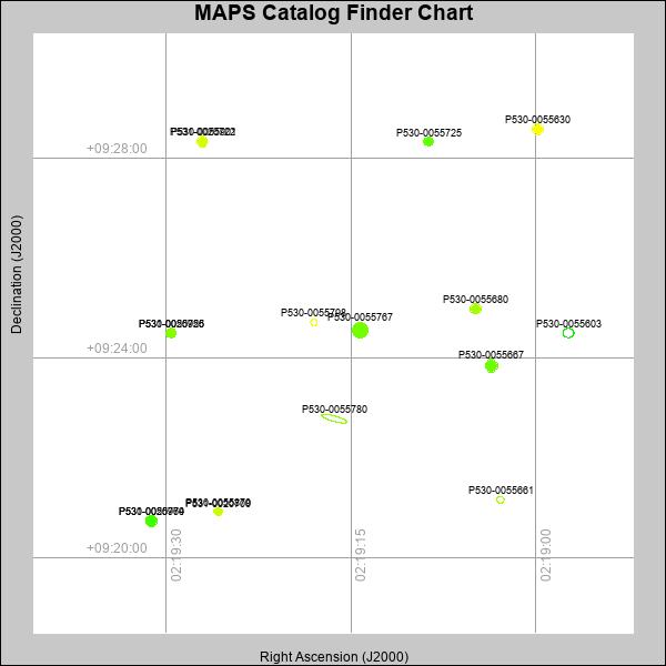 |
| Stars (point sources) are represented by filled circles. Galaxies (Extended objects) are represented by ellipses. The size of the object is an indication of its brightness (the O magnitude is printed next to each object). The color of the object indicates the actual color of the object. |
Your search returned 17 objects.
Download an ASCII text file of your results: /downloads/MAPS_output.24424224956.txt
MAPS Catalog Data for 17matching objects:
| IAU Name | raJ | declJ | magdo | magio | colord | colori | diao | thetaJO | ello | galnodo |
|---|---|---|---|---|---|---|---|---|---|---|
| MAPS-P530-0055767 | 02:19:14.243 | +09:24:32.80 | 13.67 | 16.93 | +1.02 | +1.57 | 16.51 | 37.14 | 0.115 | 0.000 |
| MAPS-P530-0055780 | 02:19:16.334 | +09:22:46.61 | 14.12 | 17.42 | -0.90 | +1.17 | 32.12 | 74.61 | 0.797 | 1.000 |
| MAPS-P530-0055667 | 02:19:03.571 | +09:23:50.39 | 15.13 | 17.49 | +0.97 | +1.55 | 13.06 | 33.91 | 0.097 | 0.100 |
| MAPS-P530-0055603 | 02:18:57.329 | +09:24:29.56 | 15.28 | 18.29 | -0.78 | +0.48 | 13.14 | 87.09 | 0.148 | 0.990 |
| MAPS-P530-0055964 | 02:19:31.169 | +09:20:43.84 | 16.41 | 18.00 | +0.79 | +1.31 | 10.63 | 32.14 | 0.076 | 0.160 |
| MAPS-P530-0055630 | 02:18:59.832 | +09:28:34.07 | 16.46 | 17.92 | +1.89 | +1.89 | 10.71 | 39.01 | 0.103 | 0.010 |
| MAPS-P530-0055901 | 02:19:27.061 | +09:28:19.48 | 16.55 | 17.96 | +1.63 | +1.74 | 10.67 | 39.35 | 0.123 | 0.010 |
| MAPS-P530-0055680 | 02:19:04.873 | +09:24:58.49 | 16.64 | 18.02 | +1.31 | +1.56 | 10.42 | 31.68 | 0.104 | 0.070 |
| MAPS-P531-0020779 | 02:19:31.177 | +09:20:44.73 | 16.70 | 18.09 | +0.76 | +1.23 | 10.04 | 116.32 | 0.039 | 0.010 |
| MAPS-P531-0020722 | 02:19:27.052 | +09:28:20.04 | 16.70 | 18.01 | +1.64 | +1.54 | 10.27 | 138.68 | 0.082 | 0.010 |
| MAPS-P530-0055926 | 02:19:29.578 | +09:24:29.49 | 16.95 | 18.16 | +0.99 | +1.40 | 9.91 | 38.99 | 0.103 | 0.100 |
| MAPS-P530-0055725 | 02:19:08.684 | +09:28:19.41 | 17.11 | 18.23 | +0.92 | +1.51 | 9.73 | 36.91 | 0.119 | 0.170 |
| MAPS-P531-0020755 | 02:19:29.582 | +09:24:30.08 | 17.16 | 18.19 | +1.12 | +1.30 | 9.29 | 160.60 | 0.028 | 0.010 |
| MAPS-P530-0055879 | 02:19:25.743 | +09:20:54.16 | 17.63 | 18.51 | +1.45 | +1.55 | 8.69 | 30.55 | 0.070 | 0.580 |
| MAPS-P530-0055661 | 02:19:02.851 | +09:21:09.27 | 17.70 | 18.51 | +1.04 | +1.30 | 8.58 | 59.48 | 0.068 | 0.550 |
| MAPS-P531-0020700 | 02:19:25.742 | +09:20:54.94 | 17.77 | 18.53 | +1.56 | +1.51 | 8.61 | 154.21 | 0.074 | 0.010 |
| MAPS-P530-0055798 | 02:19:17.983 | +09:24:42.41 | 17.98 | 18.63 | +2.04 | +1.86 | 8.15 | 75.49 | 0.065 | 0.620 |
This page was generated at Wed, 24 Apr 2024 22:49:56 -0500 and took 0.288 seconds to serve.