Finder Charts
The queried region:
| Longitude/Right Ascension: | 01:43:17.1 | |
| Latitude/Declination: | 3.9130750 (degrees) | |
| Field Width: | 10.0 (arcminutes) | |
| Coordinate System: | J2000 |
|
MAPS Catalog Finder Chart Query Results
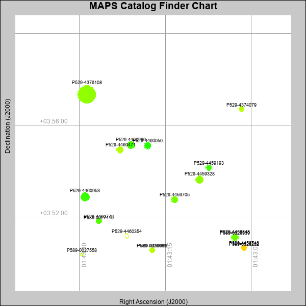 |
| Stars (point sources) are represented by filled circles. Galaxies (Extended objects) are represented by ellipses. The size of the object is an indication of its brightness (the O magnitude is printed next to each object). The color of the object indicates the actual color of the object. |
Your search returned 19 objects.
Download an ASCII text file of your results: /downloads/MAPS_output.24424224026.txt
MAPS Catalog Data for 19matching objects:
| IAU Name | raJ | declJ | magdo | magio | colord | colori | diao | thetaJO | ello | galnodo |
|---|---|---|---|---|---|---|---|---|---|---|
| MAPS-P529-4376108 | 01:43:28.701 | +03:57:20.98 | 10.80 | 16.13 | +1.21 | +2.11 | 38.56 | 9.60 | 0.165 | 0.020 |
| MAPS-P529-4460953 | 01:43:29.000 | +03:52:52.69 | 14.04 | 17.50 | +0.72 | +1.47 | 18.55 | 6.30 | 0.126 | 0.000 |
| MAPS-P529-4459328 | 01:43:09.024 | +03:53:38.37 | 14.97 | 17.81 | +1.19 | +1.62 | 16.09 | 18.38 | 0.119 | 0.000 |
| MAPS-P529-4460296 | 01:43:21.005 | +03:55:08.18 | 15.00 | 17.80 | +0.76 | +1.44 | 16.30 | 3.57 | 0.150 | 0.010 |
| MAPS-P589-0026339 | 01:43:02.870 | +03:51:06.58 | 15.33 | 17.82 | +0.58 | +1.26 | 11.25 | 1.28 | 0.035 | 0.010 |
| MAPS-P529-4458848 | 01:43:02.863 | +03:51:06.91 | 15.57 | 17.97 | +0.98 | +1.49 | 14.90 | 10.64 | 0.137 | 0.010 |
| MAPS-P529-4460050 | 01:43:18.115 | +03:55:06.44 | 15.60 | 17.98 | +0.60 | +1.34 | 15.02 | 173.44 | 0.157 | 0.010 |
| MAPS-P529-4459705 | 01:43:13.386 | +03:52:45.56 | 15.75 | 18.04 | +1.05 | +1.49 | 13.94 | 6.67 | 0.064 | 0.010 |
| MAPS-P529-4460471 | 01:43:22.932 | +03:54:56.02 | 15.97 | 18.09 | +1.44 | +1.62 | 14.07 | 5.22 | 0.138 | 0.010 |
| MAPS-P529-4459193 | 01:43:07.416 | +03:54:09.33 | 16.46 | 18.27 | +0.75 | +1.32 | 12.84 | 8.26 | 0.104 | 0.010 |
| MAPS-P589-0026262 | 01:43:01.204 | +03:50:39.86 | 17.04 | 18.44 | +1.85 | +1.65 | 8.93 | 151.42 | 0.082 | 0.010 |
| MAPS-P529-4458718 | 01:43:01.202 | +03:50:40.07 | 17.18 | 18.55 | +2.23 | +1.88 | 11.78 | 175.37 | 0.144 | 0.010 |
| MAPS-P589-0027419 | 01:43:26.621 | +03:51:49.22 | 17.42 | 18.64 | +0.81 | +1.24 | 8.13 | 102.67 | 0.018 | 0.010 |
| MAPS-P529-4460354 | 01:43:21.727 | +03:51:11.07 | 17.48 | 19.40 | +1.32 | +1.66 | 13.07 | 23.27 | 0.368 | 0.980 |
| MAPS-P529-4460772 | 01:43:26.601 | +03:51:49.31 | 17.50 | 18.73 | +0.86 | +1.37 | 11.52 | 4.56 | 0.190 | 0.010 |
| MAPS-P529-4374079 | 01:43:01.658 | +03:56:42.60 | 17.60 | 18.78 | +1.44 | +1.55 | 10.97 | 28.57 | 0.137 | 0.010 |
| MAPS-P589-0027558 | 01:43:29.541 | +03:50:22.52 | 17.72 | 19.62 | +0.90 | +1.51 | 10.10 | 99.65 | 0.426 | 0.990 |
| MAPS-P589-0026982 | 01:43:17.331 | +03:50:33.84 | 17.82 | 19.00 | +1.40 | +1.63 | 8.14 | 126.50 | 0.146 | 0.620 |
| MAPS-P529-4459995 | 01:43:17.316 | +03:50:33.72 | 17.95 | 19.08 | +1.44 | +1.60 | 11.15 | 154.24 | 0.256 | 0.010 |
This page was generated at Wed, 24 Apr 2024 22:40:26 -0500 and took 0.244 seconds to serve.