Finder Charts
The queried region:
| Longitude/Right Ascension: | 01:15:06.9 | |
| Latitude/Declination: | -1.7459417 (degrees) | |
| Field Width: | 10.0 (arcminutes) | |
| Coordinate System: | J2000 |
|
MAPS Catalog Finder Chart Query Results
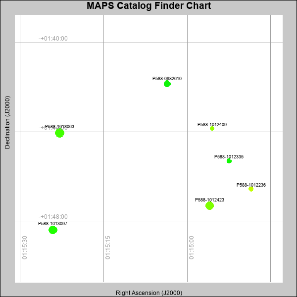 |
| Stars (point sources) are represented by filled circles. Galaxies (Extended objects) are represented by ellipses. The size of the object is an indication of its brightness (the O magnitude is printed next to each object). The color of the object indicates the actual color of the object. |
Your search returned 7 objects.
Download an ASCII text file of your results: /downloads/MAPS_output.19424104046.txt
MAPS Catalog Data for 7matching objects:
| IAU Name | raJ | declJ | magdo | magio | colord | colori | diao | thetaJO | ello | galnodo |
|---|---|---|---|---|---|---|---|---|---|---|
| MAPS-P588-1012423 | 01:14:56.004 | -01:47:19.15 | 12.61 | 17.05 | +1.09 | +1.89 | 17.80 | 17.05 | 0.065 | 0.000 |
| MAPS-P588-1013097 | 01:15:24.121 | -01:48:24.03 | 12.75 | 17.13 | +0.58 | +1.70 | 18.29 | 11.42 | 0.157 | 0.000 |
| MAPS-P588-1013063 | 01:15:22.901 | -01:44:02.81 | 12.79 | 17.13 | +0.76 | +1.77 | 19.91 | 127.88 | 0.300 | 0.000 |
| MAPS-P588-0982610 | 01:15:03.566 | -01:41:50.28 | 14.34 | 17.66 | +0.42 | +1.56 | 14.68 | 179.83 | 0.177 | 0.010 |
| MAPS-P588-1012335 | 01:14:52.458 | -01:45:18.24 | 16.80 | 18.44 | +0.28 | +1.29 | 10.46 | 161.81 | 0.128 | 0.010 |
| MAPS-P588-1012236 | 01:14:48.521 | -01:46:33.69 | 17.52 | 18.71 | +1.51 | +1.76 | 9.69 | 7.67 | 0.168 | 0.010 |
| MAPS-P588-1012409 | 01:14:55.546 | -01:43:50.32 | 17.70 | 18.72 | +1.23 | +1.63 | 9.19 | 1.98 | 0.123 | 0.010 |
This page was generated at Fri, 19 Apr 2024 10:40:46 -0500 and took 0.179 seconds to serve.